
Revision summary
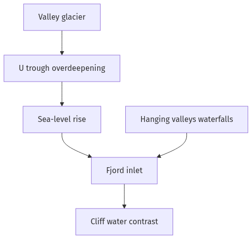
Pleistocene valley glaciers cut deep U-shaped coastal troughs. Overdeepening left a basin below later sea level and a shallower mouth. Post-glacial sea-level rise drowned the troughs into fjords. Hanging valleys and waterfalls feed the steep walls. The picturesque quality is the contrast of still water, cliffs, ice, and tiny settlements.
Model answer
Copper italics in this answer — like this — are the key facts. Each one is unpacked in the Facts & figures rail.
Introduction
Fjords are long, steep-sided sea inlets that occupy drowned glacial valleys. They look dramatic because ice once cut deep U-shaped troughs that the sea later flooded.
Body
How fjords are formed
- During cold phases of the Pleistocene, thick valley glaciers flowed to the coast in high-latitude mountains such as Norway, Greenland, Alaska, Chile, and South Island, New Zealand.
- Ice plucked and abraded the valley floor and walls, turning a river V-shape into a deep U-shaped trough with a hanging tributary network.
- The glacier often overdeepened the trough so the rock basin sat below later sea level, with a shallower rock threshold or moraine near the mouth.
- When the ice melted, global sea level rose, and the sea drowned the trough to form a narrow inlet with very deep water inland of that threshold.
- Rivers and waterfalls now enter from hanging valleys, while the inner basin stays calm compared with the open ocean.
Why they look picturesque
- Steep rock walls rise almost from the water, so the eye sees a sharp contrast of cliff, forest or snow, and a still, branching channel.
- Waterfalls, hanging valleys, and narrow sky give a vertical landscape that ordinary coastal plains do not have.
- Clear water, reflections, and changing light on ice, rock, and village wooden houses make scenes that painters and travellers record.
- Relative isolation of farms and fishing hamlets on tiny benches of land adds human scale against huge walls.
- In polar and sub-polar belts the same inlets also show glaciers, icebergs, or the aurora, which adds movement and colour to the drowned trough.
Limits of the picture
- Not every drowned coast is a fjord; rias are drowned river valleys without the glacial overdeepening and U-profile.
- Tourism and cruise traffic can crowd the same views that isolation once protected.
Flow diagram
Conclusion
Fjords are glacial troughs drowned by post-glacial seas, with deep inner basins and hanging valleys. Their picturesque power comes from that vertical contrast of water, wall, and ice, and it will last only if the landform is not treated as a mere backdrop for unplanned tourism.
Quick related
Students also ask
-
Why did human development fail to keep pace with economic development in India?
Next question on this syllabus topic (2023 · Q16). View answer →
-
Are fjords only in Norway?
Norway is the type region. The same glacial drowning occurs in other high-latitude west coasts listed above.
-
Did the sea cut the fjord walls?
Ice cut the trough. The sea later flooded it. Waves only trim the outer coasts.
Same topic · past papers
UPSC has asked this before
These previous-year questions sit on the same topic. Open one to practise the earlier ask.
-
2025 · Q7 · GS I · 10 marks
What are Tsunamis? How and where are they formed? What are their consequences? Explain with examples.
More from this topic
Q17 · UPSC Mains 2026 · GS I · 15 marks · Solution
Analyze the major drivers of human-induced land-use changes in India and their geographical consequences.
World's Physical Geography
Anthropogenic pressures driven by population growth and economic development are the primary catalysts of rapid land-use and land-cover change (LULCC) across India. Agricultural expansion and intensive multi-cropping, particularly
Q16 · UPSC Mains 2026 · GS I · 15 marks · Solution
"The centre of global trade is gradually shifting from the Atlantic region to the Indo-Pacific region." Examine this statement.
World's Physical Geography
• The global center of economic gravity has decisively shifted from the Euro-Atlantic axis to the Indo-Pacific. • The rise of China, Southeast Asia, and India as primary manufacturing and consumption hubs drives this transition. • Vital maritime chokepoints like the Malacca Strait serve as critical arteries for global energy and merchant trade. • Mega free-trade agreements such as RCEP and IPEF have established new regional trade and rule-making architectures. • Post-pandemic supply chain vulnerabilities have accelerated diversification strategies like 'China-plus-one' and 'friend-shoring'. • Control over critical mineral supply chains powers the ongoing digital and green energy transitions in the region. • Sustaining this geo-economic shift requires robust multilateral frameworks, freedom of navigation, and rules-based maritime governance.
Q14 · UPSC Mains 2026 · GS I · 15 marks · Solution
Compare the Loo, Chinook and Foehn winds with respect to their regions of prevalence, their nature and climatic impacts.
World's Physical Geography
• Local winds like the Loo, Chinook, and Foehn are driven by distinct regional pressure gradients and orographic barriers. • The Loo prevails over the Indo-Gangetic Plain, the Chinook along the Rockies' eastern slopes, and the Foehn across the northern Alpine valleys. • The Loo is a scorching, dust-laden convective surface wind generated by intense summer continental heating. • Both the Chinook and Foehn are warm, dry katabatic winds formed via rapid adiabatic compression on the leeward sides of mountains. • The Loo induces severe agricultural stress, crop wilting, and high health risks like heat strokes in South Asia. • Chinooks act as 'snow eaters' in North America, rapidly melting winter snowpacks and opening up pasturelands for grazing. • Foehn winds accelerate Alpine snowmelt, which simultaneously triggers hazardous avalanches and elevates regional wildfire risks.