
Revision summary
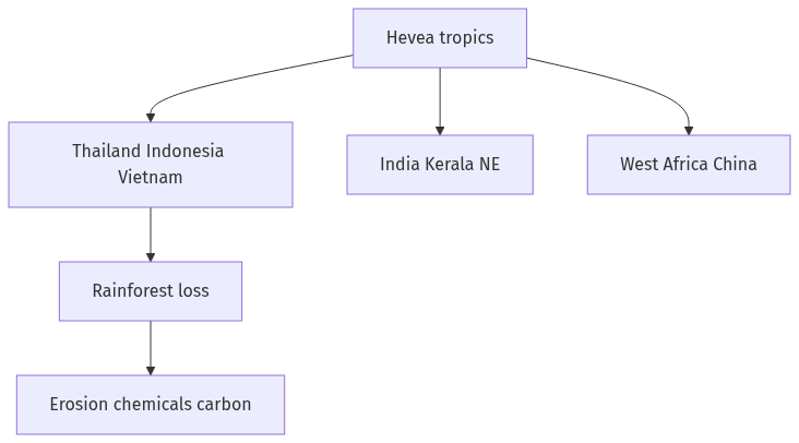
Hevea rubber is an equatorial crop now centred on Thailand, Indonesia, and Vietnam. Malaysia, India, China, and West Africa complete the main map; Amazonia is no longer the export core. Plantation advance replaces rainforest with monoculture and fragments wildlife corridors. Erosion, pesticides, mill waste, and carbon loss are the working environmental costs. Climate change tightens the rain and disease window for the same belt.
Model answer
Copper italics in this answer — like this — are the key facts. Each one is unpacked in the Facts & figures rail.
Introduction
Natural rubber is an equatorial crop of Hevea brasiliensis, native to the Amazon and now grown mainly in South-East Asia. The map of producers is also a map of rainforest loss, monoculture, and chemical stress.
Body
Distribution of producing countries
- Thailand, Indonesia, and Vietnam are the leading Asian producers, with Malaysia still important though it has shifted some land to oil palm.
- India grows plantation rubber in Kerala’s midlands and in parts of the north-east and Andaman belt, a smaller but regionally dense share.
- China has expanded in Yunnan and on Hainan, often at the climatic edge of the tree.
- West Africa, especially Côte d’Ivoire and others on the Guinea coast, is a growing African pole.
- Latin America, the plant’s home, is a smaller exporter today because of South American leaf blight and later plantation geography.
- The belt is wet equatorial and monsoon margins, roughly within the tropics, because Hevea needs rain, heat, and a dry tap season that is not a true temperate winter.
Forest and biodiversity issues
- Conversion of lowland rainforest to rubber, especially in mainland South-East Asia and on Indonesian islands, cuts habitat for elephants, hornbills, and other forest species.
- Monoculture blocks are biological deserts compared with mixed dipterocarp forest, even when the crop is a tree.
- Expansion into montane and seasonal forests, as in parts of the Mekong uplands, fragments corridors and raises landslide risk on steep grades.
Soil, water, chemicals, and climate
- Clean-weeded slopes erode; laterite and poor tropical soils lose organic matter under repeated tapping landscapes.
- Pesticides, fertilisers, and mill effluent pollute streams that village fisheries still use.
- Smoke-houses and processing can add local air and water loads around factory towns.
- Climate change shifts the rain window and raises disease pressure, while producers also face the irony that rubber replaced forest that stored more carbon.
- Labour and land conflicts sit beside ecology: smallholders may over-tap, and concessions may ignore customary forest.
A fair close on distribution and harm
- The environmental issue is not the tree in a home garden; it is landscape-scale replacement of rainforest by one industrial species across the equatorial producing states.
Flow diagram
Conclusion
Rubber production clusters in equatorial South-East Asia, with India, China, and West Africa as other nodes. Those countries face deforestation, monoculture, erosion, chemicals, and a tightening climate envelope; the map of latex is a map of tropical forest under pressure.
Quick related
Students also ask
-
Mention the significance of straits and isthmus in international trade.
Next question on this syllabus topic (2022 · Q16). View answer →
-
Why did Asia overtake Brazil in rubber?
Seed transfer, plantation capital, and leaf blight in the Amazon reversed the crop’s home advantage.
-
Is smallholder rubber environmentally safe?
Mixed plots are gentler than industrial blocks. At landscape scale even smallholders can still replace forest.
Same topic · past papers
UPSC has asked this before
These previous-year questions sit on the same topic. Open one to practise the earlier ask.
More from this topic
Q17 · UPSC Mains 2026 · GS I · 15 marks · Solution
Analyze the major drivers of human-induced land-use changes in India and their geographical consequences.
World's Physical Geography
Anthropogenic pressures driven by population growth and economic development are the primary catalysts of rapid land-use and land-cover change (LULCC) across India. Agricultural expansion and intensive multi-cropping, particularly
Q16 · UPSC Mains 2026 · GS I · 15 marks · Solution
"The centre of global trade is gradually shifting from the Atlantic region to the Indo-Pacific region." Examine this statement.
World's Physical Geography
• The global center of economic gravity has decisively shifted from the Euro-Atlantic axis to the Indo-Pacific. • The rise of China, Southeast Asia, and India as primary manufacturing and consumption hubs drives this transition. • Vital maritime chokepoints like the Malacca Strait serve as critical arteries for global energy and merchant trade. • Mega free-trade agreements such as RCEP and IPEF have established new regional trade and rule-making architectures. • Post-pandemic supply chain vulnerabilities have accelerated diversification strategies like 'China-plus-one' and 'friend-shoring'. • Control over critical mineral supply chains powers the ongoing digital and green energy transitions in the region. • Sustaining this geo-economic shift requires robust multilateral frameworks, freedom of navigation, and rules-based maritime governance.
Q14 · UPSC Mains 2026 · GS I · 15 marks · Solution
Compare the Loo, Chinook and Foehn winds with respect to their regions of prevalence, their nature and climatic impacts.
World's Physical Geography
• Local winds like the Loo, Chinook, and Foehn are driven by distinct regional pressure gradients and orographic barriers. • The Loo prevails over the Indo-Gangetic Plain, the Chinook along the Rockies' eastern slopes, and the Foehn across the northern Alpine valleys. • The Loo is a scorching, dust-laden convective surface wind generated by intense summer continental heating. • Both the Chinook and Foehn are warm, dry katabatic winds formed via rapid adiabatic compression on the leeward sides of mountains. • The Loo induces severe agricultural stress, crop wilting, and high health risks like heat strokes in South Asia. • Chinooks act as 'snow eaters' in North America, rapidly melting winter snowpacks and opening up pasturelands for grazing. • Foehn winds accelerate Alpine snowmelt, which simultaneously triggers hazardous avalanches and elevates regional wildfire risks.