
Revision summary
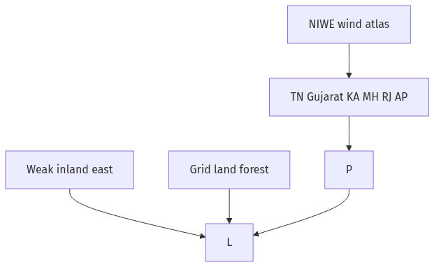
NIWE maps strong onshore wind in Tamil Nadu, Gujarat, Karnataka, Maharashtra, Rajasthan, and Andhra Pradesh. Offshore potential is large but still little built. Turbines stay clustered because wind density, land, forests, and evacuation are uneven. Early policy and substations locked in those corridors. Hybrids and offshore can widen the map; they cannot put a farm in every district.
Model answer
Copper italics in this answer — like this — are the key facts. Each one is unpacked in the Facts & figures rail.
Introduction
India has a large wind resource on western and southern corridors, mapped by the National Institute of Wind Energy. Installed capacity is serious, yet turbines cluster in a few states because wind, land, and the grid do not spread evenly.
Body
Potential
- NIWE’s wind atlas shows strong winds along Tamil Nadu’s Palghat gap, Gujarat’s coast and Kachchh, interior Karnataka, western Maharashtra, Rajasthan, and Andhra Pradesh.
- Onshore potential is the present workhorse; offshore estimates for Gujarat and Tamil Nadu are large but still early in deployment.
- Wind matches evening and monsoon pulses in some belts, which can complement solar’s daytime peak if the grid can take both.
- Manufacturing and a long private-sector history since the 1990s make wind a mature Indian renewable, not a pilot toy.
Why spatial spread is limited
- Mean wind power density is high only in corridors; the eastern plains, interior north, and much of the north-east are weak for utility turbines.
- Land for large rotors is scarce near cities, and forest or agricultural objection blocks many otherwise windy ridges.
- Grid evacuation, until recent green corridors, lagged in new districts, so developers stayed where substations and old farms already existed, as at Muppandal.
- Intermittency needs balancing power and forecasting; weaker state utilities hesitated to add remote wind.
- Policy and renewable purchase history favoured early movers such as Tamil Nadu and Gujarat, which locked in a clustered map.
Way forward for spread
- Hybrid wind–solar parks, better forecasting, and offshore pilots can widen the map without pretending every district is Denmark.
Flow diagram
Conclusion
India’s wind potential is real on western-southern corridors and in offshore estimates. Limited spatial spread follows the wind itself, land and forest limits, and a grid that grew around the first farms rather than around every state equally.
Quick related
Students also ask
-
The political and administrative reorganization of states and territories has been a continuous ongoing process since the mid-nineteenth century. Discuss with examples.
Next question on this syllabus topic (2022 · Q11). View answer →
-
Is wind potential low in India?
No. It is high in defined corridors. The question is spread, not the existence of a resource.
-
Why not put turbines everywhere like solar?
Solar needs sun, which is wide. Utility wind needs a mean speed and a clear fetch that most inland districts lack.
Same topic · past papers
UPSC has asked this before
These previous-year questions sit on the same topic. Open one to practise the earlier ask.
-
2020 · Q16 · GS I · 15 marks
India has immense potential of solar energy though there are regional variations in its developments. Elaborate. -
2024 · Q14 · GS I · 15 marks
The groundwater potential of the gangetic valley is on a serious decline. How may it affect the food security of India?
More from this topic
Q17 · UPSC Mains 2026 · GS I · 15 marks · Solution
Analyze the major drivers of human-induced land-use changes in India and their geographical consequences.
World's Physical Geography
Anthropogenic pressures driven by population growth and economic development are the primary catalysts of rapid land-use and land-cover change (LULCC) across India. Agricultural expansion and intensive multi-cropping, particularly
Q16 · UPSC Mains 2026 · GS I · 15 marks · Solution
"The centre of global trade is gradually shifting from the Atlantic region to the Indo-Pacific region." Examine this statement.
World's Physical Geography
• The global center of economic gravity has decisively shifted from the Euro-Atlantic axis to the Indo-Pacific. • The rise of China, Southeast Asia, and India as primary manufacturing and consumption hubs drives this transition. • Vital maritime chokepoints like the Malacca Strait serve as critical arteries for global energy and merchant trade. • Mega free-trade agreements such as RCEP and IPEF have established new regional trade and rule-making architectures. • Post-pandemic supply chain vulnerabilities have accelerated diversification strategies like 'China-plus-one' and 'friend-shoring'. • Control over critical mineral supply chains powers the ongoing digital and green energy transitions in the region. • Sustaining this geo-economic shift requires robust multilateral frameworks, freedom of navigation, and rules-based maritime governance.
Q14 · UPSC Mains 2026 · GS I · 15 marks · Solution
Compare the Loo, Chinook and Foehn winds with respect to their regions of prevalence, their nature and climatic impacts.
World's Physical Geography
• Local winds like the Loo, Chinook, and Foehn are driven by distinct regional pressure gradients and orographic barriers. • The Loo prevails over the Indo-Gangetic Plain, the Chinook along the Rockies' eastern slopes, and the Foehn across the northern Alpine valleys. • The Loo is a scorching, dust-laden convective surface wind generated by intense summer continental heating. • Both the Chinook and Foehn are warm, dry katabatic winds formed via rapid adiabatic compression on the leeward sides of mountains. • The Loo induces severe agricultural stress, crop wilting, and high health risks like heat strokes in South Asia. • Chinooks act as 'snow eaters' in North America, rapidly melting winter snowpacks and opening up pasturelands for grazing. • Foehn winds accelerate Alpine snowmelt, which simultaneously triggers hazardous avalanches and elevates regional wildfire risks.