
Revision summary
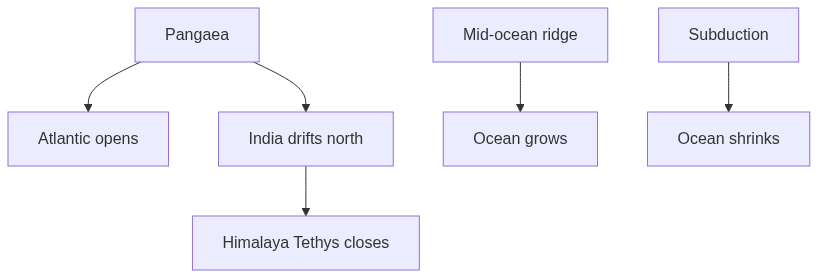
Plate tectonics moves crust: new seafloor at ridges, destruction at trenches, collision of continents. The Atlantic and Red Sea show growth of ocean basins; the Pacific trenches show consumption. India's northward drift closed the Tethys and built the Himalaya, changing both continent shape and climate. Rifts such as East Africa may birth new seas. These size and shape changes run over millions of years, not over a planning decade. The school atlas is a freeze-frame of that motion.
Model answer
Copper italics in this answer — like this — are the key facts. Each one is unpacked in the Facts & figures rail.
Introduction
Continents and oceans look fixed on a school atlas. On a clock of millions of years they crawl. The crust is broken into plates. Where plates pull apart, an ocean is born. Where they meet, an ocean may die and a mountain may rise. Shape and size of basins and continents are the slow drawing of that motion.
Body
Spreading: oceans grow
- Mid-ocean ridges: Magma rises and new seafloor forms where plates diverge.
- Atlantic opening: The ocean has been widening since Pangaea split, and Africa and South America still show the jigsaw.
- Red Sea and Gulf of Aden: These are living young ocean basins in a rift stage.
- Indian Ocean story: India once sat against Africa and Madagascar; northward drift opened ocean and closed older seaways.
- Size increase: An ocean basin grows at a spreading ridge over geological time.
Subduction: oceans shrink, arcs form
- Trenches: Where a plate dives, seafloor is destroyed along the Pacific Ring of Fire in Japan, the Andes and Indonesia.
- Ocean closure: An ocean can shrink and die when subduction outruns spreading.
- Tethys closed: India met Asia, and the old ocean's sediments now sit in the Himalaya and Tibetan Plateau.
- Continental shape change: Continents rarely subduct wholesale because they are buoyant, but collision crumples and shortens their edges.
- Ongoing push: India is still driving into Asia, so the collision zone thickens and shortens today on a geological clock.
Rift, transform, and deep time
- East African Rift: Continental rifting may split a new sea if the process continues.
- Transform faults: The San Andreas type slides plates sideways and changes coast shape without creating much new crust.
- Supercontinent cycles: Pangaea is the famous last assembly in a longer gather-and-break history.
- River and climate effects: Himalayan rivers reverse or capture, and mountain rise plus seaway opening, such as the Drake Passage, change climate.
- Mediterranean leftover: The sea is a remnant of Tethys, not a permanent feature.
- Not a human lifetime: Changes in shape and size are plate kinematics plus millions of years.
Flow diagram
Conclusion
Plates spread, sink and collide. Oceans grow at ridges and shrink at trenches. Continents rift, crash and crumple, as India still does against Asia. The atlas is a snapshot of that long motion.
Quick related
Students also ask
-
Achieving sustainable growth with emphasis on environmental protection could come into conflict with poor people's needs in a country like India - Comment.
Next question on this syllabus topic (2025 · Q19). View answer →
-
Are continents floating freely?
They ride plates. The plate may be bigger than the dry land and include seafloor.
-
Will the Himalaya stop growing?
As long as India keeps pushing, the belt keeps thickening, though erosion also wears it down.
Same topic · past papers
UPSC has asked this before
These previous-year questions sit on the same topic. Open one to practise the earlier ask.
More from this topic
Q17 · UPSC Mains 2026 · GS I · 15 marks · Solution
Analyze the major drivers of human-induced land-use changes in India and their geographical consequences.
World's Physical Geography
Anthropogenic pressures driven by population growth and economic development are the primary catalysts of rapid land-use and land-cover change (LULCC) across India. Agricultural expansion and intensive multi-cropping, particularly
Q16 · UPSC Mains 2026 · GS I · 15 marks · Solution
"The centre of global trade is gradually shifting from the Atlantic region to the Indo-Pacific region." Examine this statement.
World's Physical Geography
• The global center of economic gravity has decisively shifted from the Euro-Atlantic axis to the Indo-Pacific. • The rise of China, Southeast Asia, and India as primary manufacturing and consumption hubs drives this transition. • Vital maritime chokepoints like the Malacca Strait serve as critical arteries for global energy and merchant trade. • Mega free-trade agreements such as RCEP and IPEF have established new regional trade and rule-making architectures. • Post-pandemic supply chain vulnerabilities have accelerated diversification strategies like 'China-plus-one' and 'friend-shoring'. • Control over critical mineral supply chains powers the ongoing digital and green energy transitions in the region. • Sustaining this geo-economic shift requires robust multilateral frameworks, freedom of navigation, and rules-based maritime governance.
Q14 · UPSC Mains 2026 · GS I · 15 marks · Solution
Compare the Loo, Chinook and Foehn winds with respect to their regions of prevalence, their nature and climatic impacts.
World's Physical Geography
• Local winds like the Loo, Chinook, and Foehn are driven by distinct regional pressure gradients and orographic barriers. • The Loo prevails over the Indo-Gangetic Plain, the Chinook along the Rockies' eastern slopes, and the Foehn across the northern Alpine valleys. • The Loo is a scorching, dust-laden convective surface wind generated by intense summer continental heating. • Both the Chinook and Foehn are warm, dry katabatic winds formed via rapid adiabatic compression on the leeward sides of mountains. • The Loo induces severe agricultural stress, crop wilting, and high health risks like heat strokes in South Asia. • Chinooks act as 'snow eaters' in North America, rapidly melting winter snowpacks and opening up pasturelands for grazing. • Foehn winds accelerate Alpine snowmelt, which simultaneously triggers hazardous avalanches and elevates regional wildfire risks.