
Revision summary
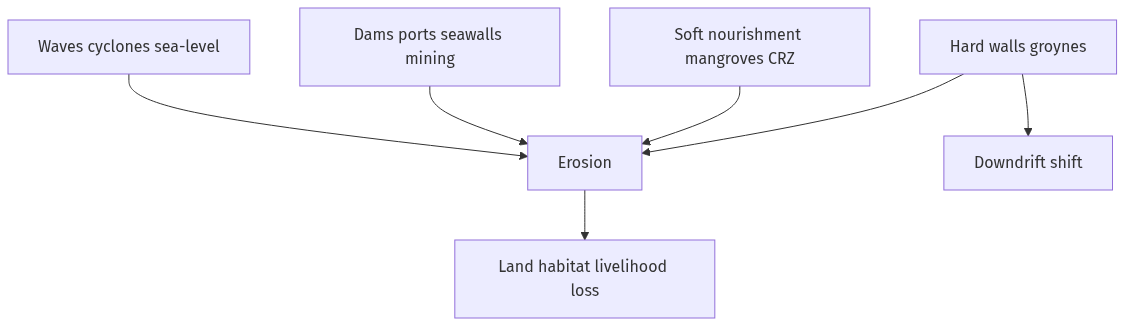
Coastal erosion is net loss of shore from waves, storms, sea-level rise and human interruption of sand. Dams, seawalls, ports, sand mining and mangrove clearance are the main human causes in India. Effects include lost villages and roads, saline intrusion, habitat loss and higher cyclone damage. Soft and nature-based methods (nourishment, dunes, mangroves) treat the sand budget; hard structures protect a point and often starve the next beach. CRZ, ICZM, sand bypassing and, where needed, managed retreat are the planning tools.
Model answer
Copper italics in this answer — like this — are the key facts. Each one is unpacked in the Facts & figures rail.
Introduction
India’s long coastline is not a fixed line. Coastal erosion is the net loss of beach and cliff to waves, currents, storms and human structures. Some stretches accrete; many, especially after a port or a seawall, retreat. Management is a choice between hard armour, soft beaches, and moving people back.
Body
Causes
- Natural: monsoon wave climate, cyclones and storm surge, longshore drift that starves a downdrift beach, sea-level rise, and river-mouth shifts that cut sand supply.
- Sediment starvation: dams on east- and west-flowing rivers trap sand that used to feed deltas and beaches.
- Hard structures: groynes, seawalls and breakwaters on one plot rob sand from the next; unplanned ports and inlets do the same at larger scale.
- Mangrove and dune destruction for shrimp ponds, real estate and sand mining removes the buffer.
- Relative sea-level rise from warming plus local subsidence (groundwater, compaction) worsens inundation and erosion.
- Inlet and creek training can focus currents that scour banks.
Effects
- Loss of land, houses and roads in fishing villages; saltwater in wells and fields.
- Habitat: nesting beaches for turtles, dunes, and mangroves shrink.
- Livelihoods: landing spaces and drying yards disappear; tourism beaches narrow.
- Infrastructure: ports, coastal roads, and defence installations need recurrent repair.
- Disaster risk: a thinner beach means waves reach inland sooner in a cyclone.
Coastal management techniques
- Hard engineering: seawalls, revetments, groynes, offshore breakwaters, tetrapods. They protect a specific asset but often shift erosion alongshore. Use where a city or port cannot retreat.
- Soft engineering: beach nourishment (placing sand), dune fencing and vegetation, and living shorelines. They need a sand budget and repetition.
- Nature-based: mangrove and shelter-belt restoration, coral and wetland buffers, and protecting dune corridors. India’s National Coastal Mission / CAMPA-type and mangrove programmes sit here.
- Hybrid: a low revetment with a nourished beach and a mangrove belt in front.
- Planning instruments: Coastal Regulation Zone (CRZ) rules, setback lines, ban on sand mining in sensitive reaches, and Integrated Coastal Zone Management (ICZM) projects (World Bank-supported in some States).
- Managed retreat: relocating the most exposed hamlets; politically hard, physically honest where the sediment budget is gone.
- Sediment management: dam flushing where feasible, bypassing sand around ports, and stopping illegal mining.
- Science: shoreline mapping (NCSCM and Survey of India-type products), monsoon monitoring, and not building in the active profile.
Principle
- Erosion is often a sand-budget problem. A wall without sand is a delay, not a cure.
Flow diagram
Conclusion
Indian coastal erosion comes from waves and storms plus dams, walls, mining and mangrove loss. Effects are lost land, salt and livelihoods. Management should prefer sand, dunes and mangroves, use hard armour only for vital assets, and keep CRZ setbacks. Shifting the scar down the coast is not protection.
Quick related
Students also ask
-
Explain the difference between computing methodology of India's Gross Domestic Product (GDP) before the year 2015 and after the year 2015.
Next question on this syllabus topic (2021 · Q1). View answer →
-
Do seawalls always save the coast?
They may save the plot behind them and increase erosion next door by reflecting waves and blocking sand.
-
Is sea-level rise the only cause?
No. Local sand starvation from dams, walls and mining often dominates a given Indian stretch.
Same topic · past papers
UPSC has asked this before
These previous-year questions sit on the same topic. Open one to practise the earlier ask.
More from this topic
Q17 · UPSC Mains 2026 · GS III · 15 marks · Solution
What are the challenges to solid waste management in India? Discuss the governmental policy framework on solid waste management. Discuss the success/failure cases of Delhi and Indore cities highlighting the salient features of their solid waste management initiatives.
Indian Economy
• Rapid urbanization has made solid waste management a critical environmental and public health crisis in India. • Key challenges include lack of source segregation, inadequate processing infrastructure, reliance on unprotected informal workers, and financially weak urban local bodies. • The policy framework relies on the SWM Rules 2016, Swachh Bharat Mission (Urban), and Plastic Waste Management Rules 2016. • Indore succeeded through 100% source segregation, zero dump-site remediation, and strict enforcement with digital monitoring. • Delhi failed due to overloaded legacy landfills (Ghazipur, Bhalswa), lack of decentralization, and fragmented municipal governance. • A successful transition requires moving to a circular economy focused on source segregation, decentralized processing, and polluter accountability.
Q16 · UPSC Mains 2026 · GS III · 15 marks · Solution
What is Agentic Artificial Intelligence (AI)? Explain its working. Describe its applications with suitable examples. Discuss the advantages, risks and challenges associated with agentic AI systems.
Indian Economy
Agentic Artificial Intelligence represents an advanced paradigm where AI systems operate with autonomy, setting goals and executing complex workflows without constant human prompts. Unlike traditional generative AI that merely responds to queries, agentic AI uses perception, planning, memory, and tool-use to achieve multi-step objectives. Its applications span across autonomous software engineering, supply chain optimization, and automated financial trading. While offering massive productivity gains and dynamic problem-solving, these systems pose significant risks including lack of transparency, alignment failures, security vulnerabilities, and ethical dilemmas. Governance frameworks and robust guardrails are essential to harness their potential safely.
Q15 · UPSC Mains 2026 · GS III · 15 marks · Solution
Mention salient features of 'Mission Drishti'. Discuss the imaging techniques used in the satellite launched on 3rd May 2026. Why is it being considered world's first satellite of its kind?
Indian Economy
Mission Drishti represents a major leap in India's space-based Earth observation capabilities, launched on 3rd May 2026. The mission employs advanced multi-spectral and hyperspectral imaging techniques to capture high-resolution data across various atmospheric and terrestrial layers. It is hailed as a global first due to its unique integration of real-time onboard edge computing with quantum encryption for secure data transmission. The satellite significantly enhances resource management, disaster response, and strategic surveillance. It aligns with India's policy of leveraging space technology for sustainable development and national security.