
Revision summary
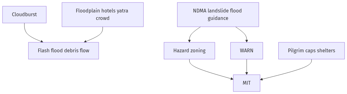
A cloudburst over a steep Uttarakhand catchment becomes a flash flood and landslide within minutes. Damage explodes when hotels and yatris occupy river beds and old slide zones. NDMA guidelines stress hazard mapping, construction control, and early warning. Mitigation is Doppler and rain gauges, slope and muck discipline, pilgrimage caps, and pre-positioned NDRF/SDRF. Rebuild above the flood line; do not restore the same unsafe shop.
Model answer
Copper italics in this answer — like this — are the key facts. Each one is unpacked in the Facts & figures rail.
Introduction
A cloudburst is a sudden, very heavy fall of rain over a small hill catchment — often more than 100 millimetres in an hour. In Uttarakhand that water becomes a flash flood and a debris flow within minutes. The Kedarnath disaster of 2013 and later local bursts showed what happens when rain, a glacial lake or moraine, and a built-up pilgrim town meet. National Disaster Management Authority guidelines on floods, landslides, and the hill States’ own plans are the checklist for mitigation.
Body
The hazard in Uttarakhand
- Steep slopes, fractured rock, and thin soil mean rain does not stay; it scours nalas and roads.
- Monsoon and westward disturbances can stack moisture against the Himalaya.
- River-bed construction, hotels on floodplains, and hydropower debris narrow the channel the cloudburst will use.
- Pilgrim peaks (Char Dham) put tens of thousands on the same narrow road on the same week.
- Landslides block rivers and create temporary lakes that burst — a second flood after the rain.
NDMA-linked measures to mitigate impact
- Land-use zoning: NDMA landslide and flood guidance asks States to map hazard zones and to forbid or strictly limit buildings on river beds, steep cut slopes, and old slide scars. Uttarakhand must enforce this on municipal and forest land, not only print an atlas.
- Regulation of construction and hydropower: stable cut-and-fill, no dumping of muck into rivers, and catchment treatment; the 2013 review already named unregulated roads and projects as force multipliers.
- Early warning: Doppler weather radar coverage for the hills, dense automatic rain gauges, and nowcast to district magistrates and temple boards; community watch on nala colour and noise as a last local signal.
- Glacial lake and moraine monitoring in upper catchments so a burst is not a complete surprise.
- Watershed and slope work: afforestation with local species, check dams that are maintained, and drainage of road cuts — as in NDMA landslide documents.
- Safe pilgrimage: compulsory registration, daily caps, weather-linked closure of tracks, designated shelters above known flood lines, and helipad and mule alternatives when the road goes.
- Building rules: two-storey limits where slopes fail, no hotels on the Ganga and Mandakini floodway, and relocation of the most exposed shops over a published timetable.
- Response structure: National Disaster Response Force and State Disaster Response Force pre-positioned in monsoon; Indian Air Force helicopters on notice; local police and home guards trained for traffic holds, not only for rescue photographs.
- Communication: redundant wireless because mobile towers fall; satellite phones at SDM and major temples.
- Public awareness: simple hill-language messages — leave the nala, do not stand on bridges, keep a three-day kit in the yatra season.
- Insurance, relief, and reconstruction that does not rebuild the same hotel on the same sandbank (NDMA “build back safer”).
- Inter-State and centre–State: IMD, Central Water Commission where rivers are gauged, and the State disaster authority must share one protocol; the Disaster Management Act, 2005 already names that chain.
What mitigation cannot claim
- It cannot stop a cloudburst. It can stop a town from sitting in the path, and it can give two hours’ warning and a drilled exit.
Flow diagram
Conclusion
Uttarakhand cloudbursts become catastrophes when rain meets unsafe buildings and a packed yatra road. NDMA flood and landslide guidance points to hazard maps, construction control, rain and lake warning, slope care, capped pilgrimage, NDRF/SDRF, and safer rebuilding. Mitigate the path and the crowd; do not pretend the mountain rain will become gentle.
Quick related
Students also ask
-
Can IMD always warn of a cloudburst in time?
Not always, because the cell is small and fast. Dense gauges, radar, and local nala watch still cut deaths if people know the exit route.
-
Why restrict Char Dham numbers?
The track and town cannot hold a cloudburst crowd. A cap and weather closure are mitigation, not hostility to faith.
Same topic · past papers
UPSC has asked this before
These previous-year questions sit on the same topic. Open one to practise the earlier ask.
-
2017 · Q18 · GS III · 15 marks
On December 2004, tsumani brought havoc on 14 countries including India. Discuss the factors responsible for occurrence of Tsunami and its effects on life and economy. In the light of guidelines of NDMA (2010) describe the mechanisms for preparedness to reduce the risk during such events. -
2025 · Q13 · GS III · 15 marks
Examine the factors responsible for depleting groundwater in India. What are the steps taken by the government to mitigate such depletion of groundwater? -
2024 · Q19 · GS III · 15 marks
India has a long and troubled border with China and Pakistan, fraught with contentious issues. Examine the conflicting issues and security challenges along the border. Also give out the development being undertaken in these areas under the Border Area Development Programme (BADP) and Border Infrastructure andManagement (BIM) Scheme.
More from this topic
Q18 · UPSC Mains 2026 · GS III · 15 marks · Solution
"Community participation is the cornerstone of effective disaster management." Analyse this statement with suitable examples from India. Also discuss the challenges to community participation and measures to strengthen it.
Disaster Management
• Locals arrive before national forces—participation owns the golden hour. • Community knowledge improves shelter siting and evacuation compliance. • Odisha cyclone preparedness is a flagship Indian example. • Aapda Mitra, SHGs and village councils extend response capacity. • Challenges: token committees, exclusion of migrants/women, volunteer burnout. • Measures: funded drills, inclusive lists, hybrid last-mile warnings. • Incentives and insurance keep volunteers in the system. • Technology alerts still need human messengers in low-connectivity pockets.
Q7 · UPSC Mains 2026 · GS III · 10 marks · Solution
Discuss how the contradiction between 'rapid infrastructure development' and 'disaster-risk reduction' in ecologically-sensitive areas of India can be managed, with suitable examples.
Disaster Management
• Eco-sensitive zones punish rushed cutting, blasting and floodplain fill. • Disasters transfer project risk onto downstream communities. • Cumulative environmental assessment should guide corridor siting. • Engineering must price drainage, slopes and seismic loads upfront. • Monsoon pauses, CRZ/ESZ rules and quarry limits are speed brakes that save lives. • Mangroves, wetlands and forests are infrastructure for risk reduction. • Himalaya, Western Ghats, coasts and Northeast each need biome-specific design. • Aim: connectivity that survives the hazard cycle, not ribbon-cutting alone.
Q18 · UPSC Mains 2024 · GS III · 15 marks · Solution
Flooding in urban areas is an emerging climate-induced disaster. Discuss the causes of this disaster. Mention the features of two such major floods in the last two decades in India. Describe the policies and frameworks in India that aim at tackling such floods.
Disaster Management
Climate-linked urban floods come from heavier downpours on sealed soil, lost wetlands, clogged drains and tidal lock. Mumbai on 26 July 2005 combined record rain, a choked Mithi and high tide; rails and the airport stopped. Chennai in late 2015 saw prolonged monsoon rain, tank and river overflow, and city-wide disruption tied to wetland loss. National response sits in the Disaster Management Act, NDMA urban-flooding guidelines, AMRUT/Smart Cities, and Wetlands Rules. The binding failure is still local: encroachment and drains that exist on a map.