
Revision summary
Groundwater in large parts of the north-west Gangetic plain is being pumped faster than it is recharged. Green Revolution paddy–wheat, tubewells, and energy subsidies are the main extraction story. CGWB over-exploited and critical blocks are the official map of decline. Lower-Ganga arsenic and other quality failures also cut usable water. India’s wheat–rice PDS buffer still depends on this belt’s irrigation. Food security risk includes falling yields, higher costs, quality in the food chain, and a weaker drought buffer.
Model answer
Copper italics in this answer — like this — are the key facts. Each one is unpacked in the Facts & figures rail.
Introduction
Groundwater levels in large parts of the Gangetic plains are falling because extraction exceeds recharge. The region has monsoon rain, snow-fed rivers, and thick alluvium that can store water. Central Ground Water Board maps of over-exploited blocks now cover much of Punjab, Haryana, and western Uttar Pradesh. That belt supplies a large share of India’s wheat and rice. Food security therefore depends not only on harvest size. It also depends on whether wells can still lift usable water in a dry summer.
Body
Why the potential is declining
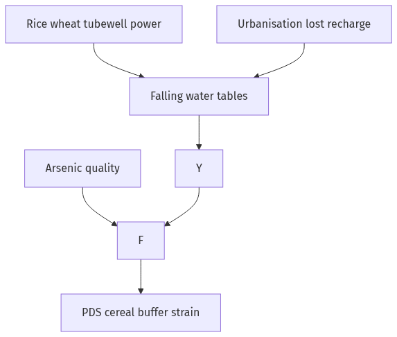
Green Revolution agriculture in the north-west Gangetic and adjacent plains linked HYV wheat and paddy to tubewells and free or cheap power. Paddy in a semi-arid Punjab autumn is a groundwater crop even when it looks like a monsoon crop. Alluvium invited deep boring. Electrification made the pump the main source of irrigation water. Recharge is limited where hardpan, urban sprawl, and vanishing ponds cut infiltration, and where canals leak less than they used to as lining spreads. Climate adds erratic rain and hotter evapotranspiration. In the lower Ganga the problem is often quality as well as quantity. Arsenic in parts of Bihar and West Bengal poisons the same aquifer people drink and, in places, irrigate from.
CGWB assessment units classed as over-exploited, critical, and semi-critical are the official language of serious decline. The Ganga itself has not dried. The usable, clean, economically lift-able groundwater is shrinking.
- Extraction: Millions of wells, energy subsidy, and a rice–wheat lock-in drive pumping.
- Recharge failure: Concretised floodplains, lost wetlands, and monsoon extremes reduce refill.
- Quality: Arsenic, salinity, and fluoride take water out of the food and drinking budget even when the well is not dry.
Pathways to food security risk
India’s calorie security still leans on MSP-supported wheat and rice from this belt, stored by the FCI and moved through the PDS. If wells fail or power-plus-depth costs rise sharply, yields fall or shift to less irrigated crops before institutions are ready. Farmers may deepen bores, idle paddy, or sell land. Nutrition security is hit if farmers abandon pulses and milk fodder for whatever still grows, or if arsenic enters the food chain. Inter-State tension over canal water will rise as groundwater ceases to be a silent buffer. The eastern Gangetic plain has unused groundwater in some pockets and a different poverty. A simple plan to move all paddy east faces power, flood, and tenure constraints.
- Buffer loss: Groundwater was the drought insurance of the Green Revolution.
- Price and PDS: Scarcer irrigation raises cost and political risk of cereal stocks.
- Regional shift: Without a just transition, decline in the north-west becomes a national food problem.
What a food-water response looks like
The reply is not only more canals. Cropping has to move away from paddy where the aquifer is mined. Direct-seeded rice, shorter-duration varieties, and diversification into maize, pulses, oilseeds, and millets where diets and MSP allow are needed. Power cannot stay a flat subsidy for midnight pumping. Recharge through ponds, floodplain protection, and aquifer storage must be treated as infrastructure. Atal Bhujal and CGWB maps are useless if panchayats never see them. Eastern intensification, if it comes, needs power and flood management. It cannot be a simple copy of Punjab.
- Demand side: Policy should seek less water per calorie, not only more water per field.
- Quality: Arsenic-safe drinking and irrigation rules are needed in the lower Ganga.
- Institutions: Agricultural and water policy must be joined, because the PDS still depends on groundwater.
Food security policy that only counts foodgrain tonnes will miss the water tonnes used under the field.
Flow diagram
Conclusion
Gangetic groundwater is in serious decline where pumps, paddy, and cheap power have mined the alluvium, and where poison as well as scarcity removes water from use. India’s cereal supply still depends on that aquifer. Food security will hold only if cropping, power pricing, recharge, and the PDS adjust together. The Jal Shakti and agricultural ministries must work as one food policy, not as two separate files.
Quick related
Students also ask
-
What are aurora australia and aurora borealis? How are these triggered?
Next question on this syllabus topic (2024 · Q15). View answer →
-
Is the whole Gangetic valley running out of water?
No. Stress is worst in the intensively pumped north-west. The east has different problems: flood, quality, and underused irrigation.
-
Can food security be saved only by more dams?
Surface water helps some command areas. Without cropping change, power reform and recharge, dams will not refill a mined aquifer.
Same topic · past papers
UPSC has asked this before
These previous-year questions sit on the same topic. Open one to practise the earlier ask.
-
2022 · Q7 · GS I · 10 marks
Examine the potential of wind energy in India and explain the reasons for their limited spatial spread. -
2020 · Q16 · GS I · 15 marks
India has immense potential of solar energy though there are regional variations in its developments. Elaborate.
More from this topic
Q17 · UPSC Mains 2026 · GS I · 15 marks · Solution
Analyze the major drivers of human-induced land-use changes in India and their geographical consequences.
World's Physical Geography
Anthropogenic pressures driven by population growth and economic development are the primary catalysts of rapid land-use and land-cover change (LULCC) across India. Agricultural expansion and intensive multi-cropping, particularly
Q16 · UPSC Mains 2026 · GS I · 15 marks · Solution
"The centre of global trade is gradually shifting from the Atlantic region to the Indo-Pacific region." Examine this statement.
World's Physical Geography
• The global center of economic gravity has decisively shifted from the Euro-Atlantic axis to the Indo-Pacific. • The rise of China, Southeast Asia, and India as primary manufacturing and consumption hubs drives this transition. • Vital maritime chokepoints like the Malacca Strait serve as critical arteries for global energy and merchant trade. • Mega free-trade agreements such as RCEP and IPEF have established new regional trade and rule-making architectures. • Post-pandemic supply chain vulnerabilities have accelerated diversification strategies like 'China-plus-one' and 'friend-shoring'. • Control over critical mineral supply chains powers the ongoing digital and green energy transitions in the region. • Sustaining this geo-economic shift requires robust multilateral frameworks, freedom of navigation, and rules-based maritime governance.
Q14 · UPSC Mains 2026 · GS I · 15 marks · Solution
Compare the Loo, Chinook and Foehn winds with respect to their regions of prevalence, their nature and climatic impacts.
World's Physical Geography
• Local winds like the Loo, Chinook, and Foehn are driven by distinct regional pressure gradients and orographic barriers. • The Loo prevails over the Indo-Gangetic Plain, the Chinook along the Rockies' eastern slopes, and the Foehn across the northern Alpine valleys. • The Loo is a scorching, dust-laden convective surface wind generated by intense summer continental heating. • Both the Chinook and Foehn are warm, dry katabatic winds formed via rapid adiabatic compression on the leeward sides of mountains. • The Loo induces severe agricultural stress, crop wilting, and high health risks like heat strokes in South Asia. • Chinooks act as 'snow eaters' in North America, rapidly melting winter snowpacks and opening up pasturelands for grazing. • Foehn winds accelerate Alpine snowmelt, which simultaneously triggers hazardous avalanches and elevates regional wildfire risks.