
Revision summary
India has high tropical solar potential nationwide. Utility parks cluster in Rajasthan, Gujarat, and the southern Deccan. Cloud, land, and grid keep the Northeast and Himalaya on rooftop and pumps. DISCOM risk and net-metering explain urban rooftop lag. ISA, NSM, and KUSUM are the policy tools to spread development.
Model answer
Copper italics in this answer — like this — are the key facts. Each one is unpacked in the Facts & figures rail.
Introduction
India sits in the tropics with a huge rooftop and wasteland estate. Solar potential is national. Deployment is regional: the Thar and western parks lead, the humid east and high Himalaya lag. Policy — ISA, NSM, KUSUM — tries to close that map.
Body
National potential
- High insolation over most of the peninsula, falling winter sun in the far north, and a long dry season in the west make photovoltaic and, in pockets, solar-thermal plausible at terawatt-hour scale.
- Co-benefits: daytime peak shaving, irrigation pumps, and a diplomatic story through the International Solar Alliance (ISA) that India co-founded.
Why development varies
- Resource: Rajasthan, Gujarat, and the western Deccan have more clear-sky kWh/m2 than the Northeast’s cloud and the Himalaya’s slope and snow.
- Land: Bhadla-type parks need square kilometres. Kerala, Bengal, and hill states lack cheap contiguous waste land; they need rooftop and agri-voltaic paths.
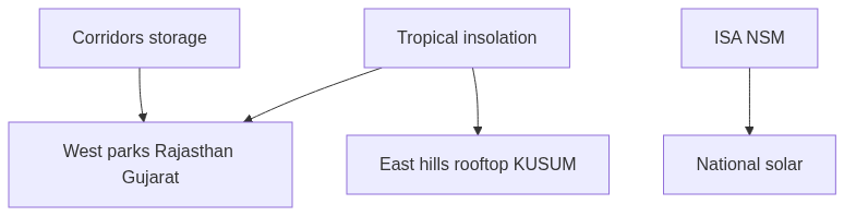
- Grid: Rajasthan parks wait on green corridors and storage; without wires, potential is stranded.
- Finance and DISCOM health: states with better payment and open-access practice attract IPPs; others stay on paper targets.
- Policy stacking: Gujarat and Rajasthan moved early on parks; some eastern states moved later on rooftop and PM-KUSUM pumps.
Regional picture
- Leaders: Rajasthan (Bhadla), Gujarat, Tamil Nadu, Karnataka, Andhra, Madhya Pradesh — utility solar plus parks.
- Middle: Maharashtra, Telangana — mixed parks and industry rooftops.
- Laggards in utility scale: many Northeastern and densely farmed Gangetic districts, where the right technology is rooftop, canal-top, and pumps, not a second Bhadla.
- Urban rooftop still lags its potential even in rich metros because of net-metering friction.
What would even the map
- Storage and round-the-clock tenders so western generation can firm eastern evenings.
- KUSUM and PM Surya Ghar to spread solar as a farm and household asset, not only a desert park.
- ISA knowledge and cheap finance for states that have cloud, not waste land.
Flow diagram
Conclusion
India’s solar potential is immense and geographically uneven in ease, not in need. Parks in the west harvest the sun; the east and hills must harvest rooftops, pumps, and a stronger grid. ISA and national missions are the political roof over that regional variation.
Quick related
Students also ask
-
Customs and traditions suppress reason leading to obscurantism. Do you agree?
Next question on this syllabus topic (2020 · Q19). View answer →
-
Is the Northeast unfit for solar?
Utility parks are harder. Rooftop, mini-grids, and hydro-solar mix still fit a cloudy, hilly load.
-
Does monsoon kill Indian solar?
It lowers capacity factor. The annual resource remains large, especially in the west.
Same topic · past papers
UPSC has asked this before
These previous-year questions sit on the same topic. Open one to practise the earlier ask.
-
2025 · Q6 · GS I · 10 marks
Explain briefly the ecological and economic benefits of solar energy generation in India with suitable examples. -
2017 · Q14 · GS I · 15 marks
Account for variations in oceanic salinity and discuss its multi-dimensional effects. (250 words).
More from this topic
Q17 · UPSC Mains 2026 · GS I · 15 marks · Solution
Analyze the major drivers of human-induced land-use changes in India and their geographical consequences.
World's Physical Geography
India's land-use change is driven by agricultural intensification, urban growth, infrastructure, mining, plantations, tourism and livelihood shifts. These changes support food, connectivity and jobs, but they also disturb hydrology, soil, habitats, microclimates, hills, coasts and access to commons. Sustainable land governance must combine mapping, carrying-capacity assessment and local participation.
Q16 · UPSC Mains 2026 · GS I · 15 marks · Solution
"The centre of global trade is gradually shifting from the Atlantic region to the Indo-Pacific region." Examine this statement.
World's Physical Geography
Global trade’s centre of gravity is moving towards the Indo-Pacific because manufacturing, consumption, energy shipping and new tech rules are concentrating between the Indian and Pacific Oceans. China-plus-one, ASEAN growth, India’s market, Malacca–Hormuz lanes, RCEP/IPEF and semiconductor corridors drive the trend. The Atlantic still matters in finance and standards, so the change is gradual rebalancing. India gains only if ports, manufacturing and sea-lane security keep pace.
Q14 · UPSC Mains 2026 · GS I · 15 marks · Solution
Compare the Loo, Chinook and Foehn winds with respect to their regions of prevalence, their nature and climatic impacts.
World's Physical Geography
The Loo is a hot, dusty pre-monsoon wind of northwestern India and the Indo-Gangetic plains. Chinook and Foehn are warm, dry downslope winds of the Rockies and Alps, formed by adiabatic compression. Their impacts differ from Indian heat stress to snowmelt and mountain hazards.