
Revision summary
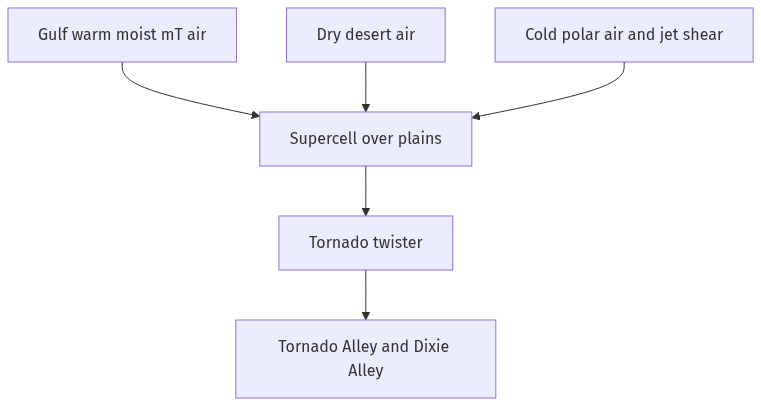
A twister is a tornado. It is a violent rotating column from cloud to ground, usually from a supercell. It is not a tropical cyclone. The scale and physics differ. The Gulf of Mexico feeds warm moist air into the southern United States. That air meets dry elevated air and cold northern flow, with strong wind shear from the jet. Tornado Alley and Dixie Alley are the result of that clash, especially in spring. Better observation in the US adds to the count, but the physical maximum is genuine.
Model answer
Copper italics in this answer — like this — are the key facts. Each one is unpacked in the Facts & figures rail.
Introduction
A twister is the popular name for a tornado. A tornado is a violently rotating column of air that touches both a cloud base, usually a supercell, and the ground. The Gulf of Mexico does not create tornadoes by itself. It supplies warm, moist air. When that air meets dry and cold streams over the interior of North America, the clash produces the most frequent tornado setting on Earth. That is why most observed twisters cluster in the United States plains and the Gulf-side South. They do not cluster on every warm coast.
Body
What a twister is
A tornado is a small-scale vortex, hundreds of metres to a few kilometres across, with extreme winds. It is often nested in a mesocyclone of a supercell thunderstorm. It is not a cyclone of the Bay of Bengal. That is a warm-core synoptic storm. It is not a dust devil. A dust devil is too shallow and has no parent thunderstorm. Waterspouts are related vortices over water. Intensity is rated on scales such as Enhanced Fujita in the US, by damage, because measuring the core is hard.
Triggering needs strong vertical wind shear to tilt and stretch rotation, a capping inversion that then breaks, and a lifting mechanism such as a dryline, a front, or outflow. The funnel is the condensed visible core. The wind field is wider.
- Scale: A tornado is local, intense, and short-lived compared with a tropical cyclone.
- Parent: The usual parent is a rotating supercell. Some weaker tornadoes have other parents.
- Hazard: Extreme wind, debris, and a narrow but catastrophic damage swath follow.
Why the Gulf of Mexico neighbourhood
The Gulf is a large source of maritime tropical (mT) air. In spring especially, that air streams north into the Mississippi valley and southern Great Plains. Aloft, dry desert air from the Mexican plateau and cold polar (cP) air from Canada create an unstable stack. Moisture sits below, dry air sits above, and a jet stream provides shear. The dryline in Texas and Oklahoma is a classic lifting line. This is Tornado Alley on the popular map. Dixie Alley nearer the Gulf has more nocturnal, rain-wrapped tornadoes in forests. Those storms are deadly because they are harder to see.
Other continents have tornadoes, including India, rarely, in thunderstorm belts. They lack this regular clash of Gulf moisture, Rocky lee trough, and polar jet at mid-latitudes, together with a large observing network. Majority observed is also a detection fact. The US has radar, spotters, and a long record. Even allowing for that, the physical concentration is real.
- Moisture fuel: Gulf mT air is the warm low-level source.
- Shear and clash: Jet, dryline, and cP fronts create rotating supercells.
- Geography: Flat plains let storms organise. The Gulf keeps supplying moisture.
The Gulf is therefore the main moisture source of the North American tornado maximum. It is not the same as a tropical cyclone basin.
What the Gulf is not
The Gulf of Mexico is also a hurricane basin. That is a different process. A hurricane is a warm-core tropical cyclone hundreds of kilometres wide. Landfalling hurricanes can spawn tornadoes in outer bands, which adds some Gulf-coast twisters to the tally. That does not explain Oklahoma in April. Moisture from a warm sea plus mid-latitude shear is the main cause. The hurricane is a smaller extra source. Other warm gulfs without that jet-and-dryline geometry do not host a Tornado Alley.
Flow diagram
Conclusion
A twister is a tornado. It is a ground-touching vortex under a parent storm. Most are seen around the inland reach of the Gulf of Mexico because Gulf moisture, dry air, and polar flow meet there often. The explanation is regional climatology. It is not a mystery of the sea itself.
Quick related
Students also ask
-
Critically analyse the proposition that there is a high correlation between India's cultural diversities and socio-economic marginalities.
Next question on this syllabus topic (2024 · Q20). View answer →
-
Do tropical cyclones in the Gulf become twisters?
Landfalling hurricanes can spawn tornadoes in their rain bands, but most US twisters are from Great Plains and Southern supercells, not from the hurricane eye.
-
Why not equally around the Bay of Bengal?
The Bay breeds tropical cyclones. It does not regularly recreate the mid-latitude dryline–polar jet–Gulf moisture sandwich of North America.
Same topic · past papers
UPSC has asked this before
These previous-year questions sit on the same topic. Open one to practise the earlier ask.
More from this topic
Q17 · UPSC Mains 2026 · GS I · 15 marks · Solution
Analyze the major drivers of human-induced land-use changes in India and their geographical consequences.
World's Physical Geography
Anthropogenic pressures driven by population growth and economic development are the primary catalysts of rapid land-use and land-cover change (LULCC) across India. Agricultural expansion and intensive multi-cropping, particularly
Q16 · UPSC Mains 2026 · GS I · 15 marks · Solution
"The centre of global trade is gradually shifting from the Atlantic region to the Indo-Pacific region." Examine this statement.
World's Physical Geography
• The global center of economic gravity has decisively shifted from the Euro-Atlantic axis to the Indo-Pacific. • The rise of China, Southeast Asia, and India as primary manufacturing and consumption hubs drives this transition. • Vital maritime chokepoints like the Malacca Strait serve as critical arteries for global energy and merchant trade. • Mega free-trade agreements such as RCEP and IPEF have established new regional trade and rule-making architectures. • Post-pandemic supply chain vulnerabilities have accelerated diversification strategies like 'China-plus-one' and 'friend-shoring'. • Control over critical mineral supply chains powers the ongoing digital and green energy transitions in the region. • Sustaining this geo-economic shift requires robust multilateral frameworks, freedom of navigation, and rules-based maritime governance.
Q14 · UPSC Mains 2026 · GS I · 15 marks · Solution
Compare the Loo, Chinook and Foehn winds with respect to their regions of prevalence, their nature and climatic impacts.
World's Physical Geography
• Local winds like the Loo, Chinook, and Foehn are driven by distinct regional pressure gradients and orographic barriers. • The Loo prevails over the Indo-Gangetic Plain, the Chinook along the Rockies' eastern slopes, and the Foehn across the northern Alpine valleys. • The Loo is a scorching, dust-laden convective surface wind generated by intense summer continental heating. • Both the Chinook and Foehn are warm, dry katabatic winds formed via rapid adiabatic compression on the leeward sides of mountains. • The Loo induces severe agricultural stress, crop wilting, and high health risks like heat strokes in South Asia. • Chinooks act as 'snow eaters' in North America, rapidly melting winter snowpacks and opening up pasturelands for grazing. • Foehn winds accelerate Alpine snowmelt, which simultaneously triggers hazardous avalanches and elevates regional wildfire risks.