
Revision summary
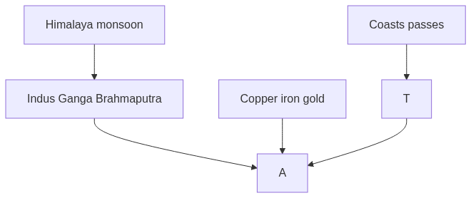
Harappan cities grew on the Indus system and later states on the Ganga plains because alluvium and monsoon rain supported surplus. The Himalaya, Ghats, and Deccan split cores of settlement and directed routes. Passes in the north-west and ports on both seas linked India to Central Asia, Rome, and South-East Asia. Copper, iron, and gold supplied tools and craft. Geography set the stage; it did not replace human institutions.
Model answer
Copper italics in this answer — like this — are the key facts. Each one is unpacked in the Facts & figures rail.
Introduction
Ancient India grew where land, water, and climate made farming, craft, and travel possible. Geography did not write history by itself, but it set the places where cities, states, and trade could last.
Body
Rivers and plains
- The Indus and its tributaries supported the Harappan cities of Mohenjo-daro, Harappa, Dholavira, and Lothal on alluvium and floodplains.
- The Ganga–Yamuna doab later carried denser farming, iron-using villages, and mahajanapadas such as Magadha, Kosala, and Kuru.
- The Himalaya fed these rivers with snowmelt and monsoon rain, so irrigation and surplus grain were possible for long seasons.
- The Brahmaputra and the delta of Bengal opened wet-rice belts and river trade toward the Bay of Bengal.
Relief, climate, and resources
- The monsoon gave a reliable crop calendar of kharif and rabi, which is why settled agriculture could support towns and taxes.
- The Western Ghats, Eastern Ghats, and the Deccan plateau created separate cores such as the Godavari–Krishna valleys and the Kaveri delta.
- Copper of the Aravalli–Khetri belt, iron of the middle Ganga and Deccan, and gold of the Kolar region supplied tools, weapons, and ornaments.
- Mountain passes such as the Khyber and Bolan linked the north-west to Central Asia and brought horses, ideas, and invaders on the same roads.
Coasts and frontiers
- The long Arabian Sea and Bay of Bengal coasts allowed ports such as Bharuch, Muziris, Arikamedu, and Tamralipti to trade with West Asia, Rome, and South-East Asia.
- Forests of the Vindhya, Western Ghats, and north-east supplied timber, elephants, and tribal labour that states tried to tap.
- Deserts of the Thar and the high Himalaya limited dense settlement, so political centres clustered on the wetter plains.
Way forward for the answer
- Treat geography as a set of opportunities and limits, not as a single cause of culture.
- Name specific rivers, passes, ports, and ores so the explanation stays concrete.
Flow diagram
Conclusion
River plains, monsoon farming, minerals, passes, and coasts together shaped where Ancient India could farm, build states, and trade. Later history still has to add technology and politics, but those choices were made inside this map.
Quick related
Students also ask
-
Bring out the socio-economic effects of the introduction of railways in different countries of the world.
Next question on this syllabus topic (2023 · Q3). View answer →
-
Did geography alone create Ancient Indian civilisation?
No. Rivers and coasts made surplus and trade possible. States, religion, and technology decided how those openings were used.
-
Why did Magadha rise later than Harappa?
The middle Ganga offered iron, forests, and rice surplus in the first millennium BCE. The Indus cities belong to an earlier river system and climate window.
Same topic · past papers
UPSC has asked this before
These previous-year questions sit on the same topic. Open one to practise the earlier ask.
-
2026 · Q17 · GS I · 15 marks
Analyze the major drivers of human-induced land-use changes in India and their geographical consequences. -
2025 · Q14 · GS I · 15 marks
Give a geographical explanation of the distribution of off-shore oil reserves of the world. How are they different from the on-shore occurrences of oil reserves?
More from this topic
Q17 · UPSC Mains 2026 · GS I · 15 marks · Solution
Analyze the major drivers of human-induced land-use changes in India and their geographical consequences.
World's Physical Geography
Anthropogenic pressures driven by population growth and economic development are the primary catalysts of rapid land-use and land-cover change (LULCC) across India. Agricultural expansion and intensive multi-cropping, particularly
Q16 · UPSC Mains 2026 · GS I · 15 marks · Solution
"The centre of global trade is gradually shifting from the Atlantic region to the Indo-Pacific region." Examine this statement.
World's Physical Geography
• The global center of economic gravity has decisively shifted from the Euro-Atlantic axis to the Indo-Pacific. • The rise of China, Southeast Asia, and India as primary manufacturing and consumption hubs drives this transition. • Vital maritime chokepoints like the Malacca Strait serve as critical arteries for global energy and merchant trade. • Mega free-trade agreements such as RCEP and IPEF have established new regional trade and rule-making architectures. • Post-pandemic supply chain vulnerabilities have accelerated diversification strategies like 'China-plus-one' and 'friend-shoring'. • Control over critical mineral supply chains powers the ongoing digital and green energy transitions in the region. • Sustaining this geo-economic shift requires robust multilateral frameworks, freedom of navigation, and rules-based maritime governance.
Q14 · UPSC Mains 2026 · GS I · 15 marks · Solution
Compare the Loo, Chinook and Foehn winds with respect to their regions of prevalence, their nature and climatic impacts.
World's Physical Geography
• Local winds like the Loo, Chinook, and Foehn are driven by distinct regional pressure gradients and orographic barriers. • The Loo prevails over the Indo-Gangetic Plain, the Chinook along the Rockies' eastern slopes, and the Foehn across the northern Alpine valleys. • The Loo is a scorching, dust-laden convective surface wind generated by intense summer continental heating. • Both the Chinook and Foehn are warm, dry katabatic winds formed via rapid adiabatic compression on the leeward sides of mountains. • The Loo induces severe agricultural stress, crop wilting, and high health risks like heat strokes in South Asia. • Chinooks act as 'snow eaters' in North America, rapidly melting winter snowpacks and opening up pasturelands for grazing. • Foehn winds accelerate Alpine snowmelt, which simultaneously triggers hazardous avalanches and elevates regional wildfire risks.