
Revision summary
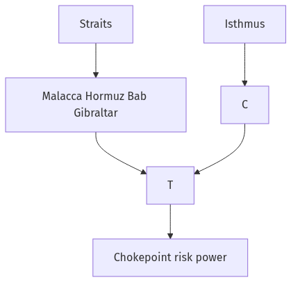
Straits are sea chokepoints; isthmuses are land necks between seas. Malacca, Hormuz, Bab el-Mandeb, Gibraltar, and Bering structure bulk and energy routes. Suez and Panama canals cut isthmuses and abolished two great capes for most liner trade. Blockage raises world freight; law and navies try to keep gates open. India’s energy and East Asian trade still pass these few gaps.
Model answer
Copper italics in this answer — like this — are the key facts. Each one is unpacked in the Facts & figures rail.
Introduction
Straits are narrow sea gates; isthmuses are narrow land bridges. Together they decide how cargo moves between oceans, which is why Malacca, Hormuz, Suez, and Panama sit at the centre of world trade and strategy.
Body
Straits as chokepoints of trade
- The Strait of Malacca is the shortest sea path between the Indian Ocean and the South China Sea, so East Asian industry and Gulf energy meet there.
- Hormuz gates Persian Gulf oil; Bab el-Mandeb gates the Red Sea approach to Suez; Gibraltar gates the Mediterranean and the Atlantic.
- The Bering Strait is a polar gate of lesser bulk trade today but of rising Arctic-route and strategic meaning.
- Dover, Palk, and the Turkish straits show that even regional seas depend on a few legal and physical gaps.
- A strait saves fuel and days; blockage by war, piracy, or tanker accident raises freight for the whole chain, not only for the two facing coasts.
Isthmuses and the canals that cut them
- An isthmus forces a long circumnavigation unless a canal, rail, or road crosses it.
- The Suez Canal cuts the Isthmus of Suez and links Europe to the Indian Ocean without the Cape, which remade steam-age empire and still carries containers and oil products.
- The Panama Canal cuts the Isthmus of Panama and links the Atlantic to the Pacific without Cape Horn, which structures American and East Asian shipping.
- Proposed Kra or other isthmus canals show that states still dream of bypassing Malacca; the geography lesson is the same: land necks tax sea trade until cut.
- The Corinth Canal is a smaller European example of the same isthmus logic.
Trade, law, and power
- UNCLOS transit and innocent-passage rules try to keep straits open as public seaways, because private closure would be a world tax.
- Navies, insurance, and pipeline or Arctic alternatives exist because chokepoint risk is priced into every long-haul cargo.
- For India, Malacca, Hormuz, and Bab el-Mandeb are the working triangle of energy and Look-East trade; an isthmus canal elsewhere would only redraw, not abolish, that dependence.
Significance in one line of argument
- Straits concentrate ships; isthmuses concentrate the temptation to dig; both concentrate political leverage over globalisation’s physical body.
Flow diagram
Conclusion
Straits shorten oceans and isthmuses block them until canals open. International trade therefore hangs on a handful of named gates—Malacca, Hormuz, Suez, Panama among them—whose openness is an economic and a strategic fact.
Quick related
Students also ask
-
Troposphere is a very significant atmospheric layer that determines weather processes. How?
Next question on this syllabus topic (2022 · Q17). View answer →
-
Can pipelines replace straits?
They can bypass some oil. Containers, bulk grain, and most general cargo still need the sea gate.
-
Is an isthmus always a canal site?
Only if politics, rock, and money allow. Many isthmuses remain portage or rail necks.
Same topic · past papers
UPSC has asked this before
These previous-year questions sit on the same topic. Open one to practise the earlier ask.
-
2021 · Q14 · GS I · 15 marks
Briefly mention the alignment of major mountain ranges of the world and explain their impact on local weather conditions, with examples. -
2018 · Q17 · GS I · 15 marks
Mention core strategies for the transformation of aspirational districts in India and explain the nature of convergence, collaboration and competition for its success. -
2017 · Q7 · GS I · 10 marks
Mention the advantages of the cultivation of pulses because of which the year 2016 was declared as the International Year of Pulses by United Nations.
More from this topic
Q17 · UPSC Mains 2026 · GS I · 15 marks · Solution
Analyze the major drivers of human-induced land-use changes in India and their geographical consequences.
World's Physical Geography
India's land-use change is driven by agricultural intensification, urban growth, infrastructure, mining, plantations, tourism and livelihood shifts. These changes support food, connectivity and jobs, but they also disturb hydrology, soil, habitats, microclimates, hills, coasts and access to commons. Sustainable land governance must combine mapping, carrying-capacity assessment and local participation.
Q16 · UPSC Mains 2026 · GS I · 15 marks · Solution
"The centre of global trade is gradually shifting from the Atlantic region to the Indo-Pacific region." Examine this statement.
World's Physical Geography
Global trade’s centre of gravity is moving towards the Indo-Pacific because manufacturing, consumption, energy shipping and new tech rules are concentrating between the Indian and Pacific Oceans. China-plus-one, ASEAN growth, India’s market, Malacca–Hormuz lanes, RCEP/IPEF and semiconductor corridors drive the trend. The Atlantic still matters in finance and standards, so the change is gradual rebalancing. India gains only if ports, manufacturing and sea-lane security keep pace.
Q14 · UPSC Mains 2026 · GS I · 15 marks · Solution
Compare the Loo, Chinook and Foehn winds with respect to their regions of prevalence, their nature and climatic impacts.
World's Physical Geography
The Loo is a hot, dusty pre-monsoon wind of northwestern India and the Indo-Gangetic plains. Chinook and Foehn are warm, dry downslope winds of the Rockies and Alps, formed by adiabatic compression. Their impacts differ from Indian heat stress to snowmelt and mountain hazards.