
Revision summary
The troposphere is the lowest, moist layer under the tropopause. A fall of temperature with height allows convection and cloud. Almost all water vapour, rain, cyclones, and the monsoon live here. The layer is deeper in the tropics, which permits taller storms. Daily weather is therefore a tropospheric process, not a stratospheric one.
Model answer
Copper italics in this answer — like this — are the key facts. Each one is unpacked in the Facts & figures rail.
Introduction
The troposphere is the lowest atmospheric layer, about eight to sixteen kilometres thick, and it holds almost all weather. Clouds, rain, storms, and the monsoon are processes of this moist, unstable slab beneath the tropopause.
Body
Why weather lives here
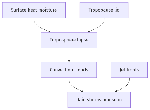
- Temperature in the troposphere generally falls with height, which allows parcels of warm air to rise, cool, and condense: that lapse rate is the engine of convection.
- Almost all water vapour sits in this layer, so evaporation from sea and land can become cloud, rain, snow, and latent-heat storms.
- The tropopause lid stops most vertical mixing into the stratosphere, which traps weather systems in a shallow working volume.
- Earth’s surface heats the bottom of the layer unevenly, which sets pressure differences, winds, and fronts.
Processes that make daily weather
- Turbulence, thunderstorms, and tropical cyclones are tropospheric towers of convection organised by wind shear and sea heat.
- Mid-latitude cyclones and fronts are tropospheric waves along the polar-front jet, which itself sits near the tropopause.
- The Indian monsoon is a seasonal tropospheric overturning: moisture-laden south-west winds, orographic lift on the Ghats and Himalaya, and rain as condensation in this layer.
- Fog, dew, and local thunderstorms are shallow tropospheric events tied to night cooling or afternoon heating.
- Greenhouse gases in this layer, especially water vapour and carbon dioxide, control the radiation that sets the lapse rate itself.
Vertical and geographic variation
- The troposphere is deeper in the tropics than at the poles, which is why tropical cumulonimbus can be taller and why polar weather is shallower and icier.
- Pollution, pollen, and most aviation weather hazards also sit here, so human life is lived inside the weather layer, not above it.
- Stratospheric ozone and the jet’s stratospheric side matter for climate, but tomorrow’s forecast is still a troposphere problem.
Significance for the examiner’s ‘how’
- Without a moist, unstable troposphere under a tropopause lid, there would be no ordinary rain cycle, no monsoon, and no cyclone; weather would not be the daily drama it is.
Flow diagram
Conclusion
The troposphere determines weather because it is warm at the base, cold at the top, full of water, and capped by the tropopause. All rain, wind systems, and storms that affect life are organised in that layer.
Quick related
Students also ask
-
Trace the rise and growth of socio-religious reform movements with special reference to Young Bengal and Brahmo Samaj.
Next question on this syllabus topic (2021 · Q2). View answer →
-
Does weather occur in the stratosphere?
Very little of the rain-and-cloud weather that affects people. The working theatre is the troposphere.
-
Why is the tropical troposphere deeper?
Stronger heating and a higher tropopause. That extra depth lets convection grow into tall cumulonimbus.
Same topic · past papers
UPSC has asked this before
These previous-year questions sit on the same topic. Open one to practise the earlier ask.
-
2026 · Q6 · GS I · 10 marks
Discuss the role of aeolian processes in desertification and land degradation.
More from this topic
Q17 · UPSC Mains 2026 · GS I · 15 marks · Solution
Analyze the major drivers of human-induced land-use changes in India and their geographical consequences.
World's Physical Geography
Anthropogenic pressures driven by population growth and economic development are the primary catalysts of rapid land-use and land-cover change (LULCC) across India. Agricultural expansion and intensive multi-cropping, particularly
Q16 · UPSC Mains 2026 · GS I · 15 marks · Solution
"The centre of global trade is gradually shifting from the Atlantic region to the Indo-Pacific region." Examine this statement.
World's Physical Geography
• The global center of economic gravity has decisively shifted from the Euro-Atlantic axis to the Indo-Pacific. • The rise of China, Southeast Asia, and India as primary manufacturing and consumption hubs drives this transition. • Vital maritime chokepoints like the Malacca Strait serve as critical arteries for global energy and merchant trade. • Mega free-trade agreements such as RCEP and IPEF have established new regional trade and rule-making architectures. • Post-pandemic supply chain vulnerabilities have accelerated diversification strategies like 'China-plus-one' and 'friend-shoring'. • Control over critical mineral supply chains powers the ongoing digital and green energy transitions in the region. • Sustaining this geo-economic shift requires robust multilateral frameworks, freedom of navigation, and rules-based maritime governance.
Q14 · UPSC Mains 2026 · GS I · 15 marks · Solution
Compare the Loo, Chinook and Foehn winds with respect to their regions of prevalence, their nature and climatic impacts.
World's Physical Geography
• Local winds like the Loo, Chinook, and Foehn are driven by distinct regional pressure gradients and orographic barriers. • The Loo prevails over the Indo-Gangetic Plain, the Chinook along the Rockies' eastern slopes, and the Foehn across the northern Alpine valleys. • The Loo is a scorching, dust-laden convective surface wind generated by intense summer continental heating. • Both the Chinook and Foehn are warm, dry katabatic winds formed via rapid adiabatic compression on the leeward sides of mountains. • The Loo induces severe agricultural stress, crop wilting, and high health risks like heat strokes in South Asia. • Chinooks act as 'snow eaters' in North America, rapidly melting winter snowpacks and opening up pasturelands for grazing. • Foehn winds accelerate Alpine snowmelt, which simultaneously triggers hazardous avalanches and elevates regional wildfire risks.