
Revision summary
A tsunami is a train of long ocean waves caused by sudden motion of the seafloor. Most begin on subduction megathrusts; landslides and volcanoes can also trigger them. In deep water they are fast and low; near shore they flood. The 2004 Sumatra quake devastated the Andamans, Tamil Nadu, Sri Lanka, the Maldives and coasts as far as Africa. Warning systems work only with drills, and mangroves take some of the blow. The Makran zone remains a local tsunami source for India’s west coast.
Model answer
Copper italics in this answer — like this — are the key facts. Each one is unpacked in the Facts & figures rail.
Introduction
A tsunami is not a high wind sea. It is a series of long waves set off when the ocean floor suddenly moves and shoves the whole water column. In deep water the wave is fast and low. Near shore it slows, stands up, and floods. A fishing village can look calm minutes before it disappears.
Body
How and where tsunamis form
- Definition: A tsunami is a train of long ocean waves from sudden seafloor motion.
- Megathrust quake: Locked subduction interfaces slip and lift or drop the seafloor.
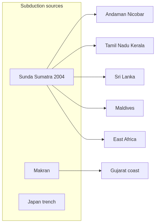
- Sunda source: The 2004 event began off Sumatra on the Sunda megathrust.
- Pacific Ring: Japan, Chile, Alaska, and Kamchatka sit on classic tsunami belts.
- Undersea landslide: A slope failure can shove the water column without a giant quake.
- Volcanic collapse: Flank failure, as with Krakatoa in 1883, can couple explosion and wave.
- Not every sea quake: Only slip that displaces the seafloor makes a tsunami.
- Deep-water speed: Waves cross oceans at jet-airliner speeds while still low in height.
- Makran trench: The Pakistan–Iran zone can send a wave toward Gujarat and Oman.
- India’s watch line: The Sunda trench to the southeast remains the main Indian Ocean neighbour.
Consequences and examples
- 2004 drowning: More than two lakh people died across the Indian Ocean basin.
- Andaman–Nicobar: Island coasts were among the first and hardest Indian hits.
- Tamil Nadu and Kerala: Fishing coasts faced fast floods hours after Sumatra.
- Sri Lanka and Maldives: Island states in the same basin shared the wave train.
- East Africa: The same event reached far western shores of the ocean.
- Saline fields: Farmland and wells die after the water leaves.
- Broken livelihoods: Boats, tourism, and coastal work collapse with the surge.
- Drawback warning: Sea withdrawal before the flood is a natural siren to run inland and uphill.
- Buffer loss: Cut mangroves and coral raise the human cost.
- INCOIS system: Buoys and tide gauges work only when beaches have drills and exits.
- Tohoku lesson: Japan’s 2011 wave showed that even prepared coasts can face walls taller than design.
Flow diagram
Conclusion
Tsunamis are long waves from sudden seafloor change, usually a megathrust quake. They grow deadly on shallow coasts. The 2004 Indian Ocean disaster, from Sumatra to Africa, is the example India cannot treat as ancient history.
Quick related
Students also ask
-
What is sea surface temperature rise? How does it affect the formation of tropical cyclones?
Next question on this syllabus topic (2024 · Q4). View answer →
-
Is a tsunami a tidal wave?
No. Tides come from the moon and sun. A tsunami comes from the crust.
-
Can the Arabian Sea produce one?
Yes. The Makran subduction zone can send a wave toward Gujarat, Oman and Pakistan.
Same topic · past papers
UPSC has asked this before
These previous-year questions sit on the same topic. Open one to practise the earlier ask.
-
2023 · Q6 · GS I · 10 marks
How are the fjords formed? Why do they constitute some of the most picturesque areas of the world?
More from this topic
Q15 · UPSC Mains 2026 · GS I · 15 marks · Solution
Analyze the role of satellite-based technologies in achieving climate-smart agriculture and food security in India.
Geophysical Phenomena
Satellite-based technologies are transforming Indian agriculture from a monsoon-dependent gamble into a precision
Q4 · UPSC Mains 2026 · GS I · 10 marks · Solution
What is the Fujiwhara effect? Explain its impact on the movement and intensity of tropical cyclones.
Geophysical Phenomena
The Fujiwhara effect occurs when two neighboring tropical cyclones rotate cyclonically around a common center due to interacting vortex dynamics. It alters the standard movement of cyclones, causing trajectories to deviate, merge, or orbit each other. In terms of intensity, the interaction can suppress the weaker storm while potentially energizing the stronger one. Understanding this phenomenon is vital for improving cyclone track forecasting in regions like the Northwest Pacific and the Bay of Bengal. Meteorological agencies use advanced numerical models to predict these complex binary cyclone interactions. Proper tracking mitigates coastal disaster risks by providing timely warnings for erratic landfall paths.
Q4 · UPSC Mains 2025 · GS I · 10 marks · Solution
How are climate change and the sea level rise affecting the very existence of many island nations? Discuss with examples.
Geophysical Phenomena
Sea level rises mainly because seawater expands as it warms and because land ice melts. Low atolls lose their freshwater lens and then their dry land to tides and storm surge. The Maldives, Tuvalu, Kiribati and the Marshall Islands live inside that risk. Legal identity, EEZ and citizenship become questions if territory disappears. Deltas such as the Sundarbans drown in a related way even though they are not island states. Climate finance and loss-and-damage talks exist because these states caused little of the carbon.