
Revision summary
Sea level rises mainly because seawater expands as it warms and because land ice melts. Low atolls lose their freshwater lens and then their dry land to tides and storm surge. The Maldives, Tuvalu, Kiribati and the Marshall Islands live inside that risk. Legal identity, EEZ and citizenship become questions if territory disappears. Deltas such as the Sundarbans drown in a related way even though they are not island states. Climate finance and loss-and-damage talks exist because these states caused little of the carbon.
Model answer
Copper italics in this answer — like this — are the key facts. Each one is unpacked in the Facts & figures rail.
Introduction
Sea level rises because oceans warm and expand, and because ice on land slides into the sea. For a large continent that change is often an inconvenience measured in centimetres on a map. For an atoll whose highest ridge is two or three metres, it is a question of whether the country still exists. That is the core of this answer.
Body
From warming to sea-level rise
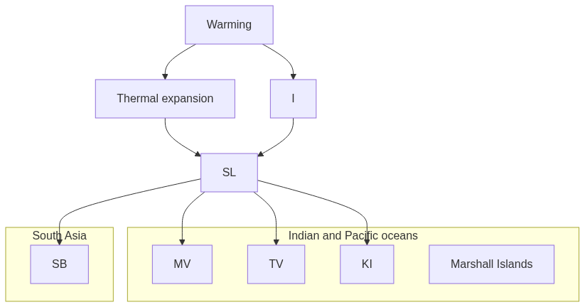
- Thermal expansion: Warm seawater occupies more volume and lifts the mean sea surface.
- Land-ice melt: Greenland, Antarctica, and mountain glaciers add water once stored on land.
- Observed rise: Global mean sea level is more than about twenty centimetres above early-twentieth-century levels.
- Faster rate: Recent decades show acceleration of that rise.
- Storm surge: Cyclones and king tides ride on a higher base and flood farther inland.
- Freshwater lens: Salt intrusion under coral islands ruins wells before houses fully drown.
Island existence and related coasts
- Maldives: Most inhabited islands sit only one to two metres above mean sea level.
- Male walls: Sea defences in the capital show a daily fight with the tide.
- Tuvalu: Some islets are already hard to live on in spring tides, which drives migration talks.
- Kiribati: Land purchase and relocation pathways show existence under legal and physical stress.
- Marshall Islands: Another Pacific atoll state faces the same arithmetic of low land and rising seas.
- Legal identity: A State needs defined territory, so drowned reefs raise EEZ and citizenship questions.
- Sundarbans cousin: Bangladesh’s delta villages drown and fields turn saline even without sovereign reefs.
- Fiji moves: Inland relocation of villages shows Pacific adaptation already under way.
- Java subsidence: North Java sinks under sea rise plus groundwater pumping, which worsens the global trend.
- Culture and work: Beaches, airports, tourism, and fish stocks erode with the shoreline.
- Loss and damage: UNFCCC finance debates exist because these states caused little of the carbon.
Flow diagram
Conclusion
Warming raises the sea by expansion and melt. Atoll states such as the Maldives, Tuvalu, and Kiribati lose fresh water and dry land first. They then lose the ordinary meaning of a country. Deltas share the flood even when they are not sovereign reefs.
Quick related
Students also ask
-
What are Tsunamis? How and where are they formed? What are their consequences? Explain with examples.
Next question on this syllabus topic (2025 · Q7). View answer →
-
Can sea walls save every atoll?
They can buy time for a capital like Male. They cannot cheaply ring every outer island, and they do not refill a poisoned well.
-
Is this only a future problem?
King tides, brackish wells and relocated Pacific villages are already present tense.
Same topic · past papers
UPSC has asked this before
These previous-year questions sit on the same topic. Open one to practise the earlier ask.
-
2023 · Q4 · GS I · 10 marks
Discuss the consequences of climate change on the food security in tropical countries. -
2021 · Q19 · GS I · 15 marks
What is Cryptocurrency? How does it affect global society? Has it been affecting Indian society also? -
2020 · Q17 · GS I · 15 marks
Examine the status of forest resources of India and its resultant impact on climate change.
More from this topic
Q15 · UPSC Mains 2026 · GS I · 15 marks · Solution
Analyze the role of satellite-based technologies in achieving climate-smart agriculture and food security in India.
Geophysical Phenomena
Satellite-based technologies are transforming Indian agriculture from a monsoon-dependent gamble into a precision
Q4 · UPSC Mains 2026 · GS I · 10 marks · Solution
What is the Fujiwhara effect? Explain its impact on the movement and intensity of tropical cyclones.
Geophysical Phenomena
The Fujiwhara effect occurs when two neighboring tropical cyclones rotate cyclonically around a common center due to interacting vortex dynamics. It alters the standard movement of cyclones, causing trajectories to deviate, merge, or orbit each other. In terms of intensity, the interaction can suppress the weaker storm while potentially energizing the stronger one. Understanding this phenomenon is vital for improving cyclone track forecasting in regions like the Northwest Pacific and the Bay of Bengal. Meteorological agencies use advanced numerical models to predict these complex binary cyclone interactions. Proper tracking mitigates coastal disaster risks by providing timely warnings for erratic landfall paths.
Q7 · UPSC Mains 2025 · GS I · 10 marks · Solution
What are Tsunamis? How and where are they formed? What are their consequences? Explain with examples.
Geophysical Phenomena
A tsunami is a train of long ocean waves caused by sudden motion of the seafloor. Most begin on subduction megathrusts; landslides and volcanoes can also trigger them. In deep water they are fast and low; near shore they flood. The 2004 Sumatra quake devastated the Andamans, Tamil Nadu, Sri Lanka, the Maldives and coasts as far as Africa. Warning systems work only with drills, and mangroves take some of the blow. The Makran zone remains a local tsunami source for India’s west coast.