
Revision summary
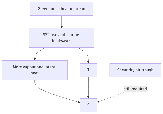
SST is the temperature of the ocean surface mixed layer that exchanges heat with the air. SST rise is long-term warming plus more marine heatwaves, because oceans store greenhouse heat. Tropical cyclones need warm water, Coriolis force, low shear and a seed disturbance. Warmer seas expand the fuel area and raise potential intensity and rainfall. Global storm counts need not jump in lockstep. Intense and rapidly intensifying storms are the clearer risk. The Bay of Bengal and the Arabian Sea must be read with monsoon shear, not with SST alone.
Model answer
Copper italics in this answer — like this — are the key facts. Each one is unpacked in the Facts & figures rail.
Introduction
Sea surface temperature (SST) is the warmth of the ocean’s skin and mixed layer. This is the water that actually touches the air. A rise in SST means that this layer is becoming warmer over years, and also during marine heatwaves. The ocean has stored most of the extra heat of a greenhouse climate. Tropical cyclones draw energy from that warmth. Warmer water does not create a storm from nothing. It does change how easily a storm can start and how strong it can become.
Body
What SST rise is
SST is measured by ships, buoys and satellites. Rise is the long-term warming of that surface, plus more frequent marine heatwaves. The energy is not only a thermometer reading. A warmer mixed layer holds more enthalpy and feeds more water vapour into the air. Global mean SST has increased over the industrial period because oceans absorbed most of the extra heat from human-caused warming. Regional maps matter. The tropical Atlantic, the Bay of Bengal and the Arabian Sea can warm at different rates. Local cyclone seasons therefore do not all tell the same story.
- Layer, not the deep abyss: Cyclones feel the upper tens of metres. A thin hot skin over cold water behaves differently from a deep warm pool.
- Moisture: Clausius–Clapeyron physics means warmer seas load the air with more vapour for rain and latent heat.
- Not a uniform bath: El Niño–Southern Oscillation and monsoon winds still rearrange warmth from year to year.
How formation and strength of cyclones change
A tropical cyclone usually needs SST near or above about 26–27°C over a sufficient depth. It also needs Coriolis force, weak vertical wind shear, and a pre-existing disturbance. SST rise widens the area and season that can meet the heat threshold. More latent heat released in the eyewall can raise the potential intensity. That is the theoretical ceiling on wind speed. Warm seas also favour rapid intensification when shear is low. Heavier rain, a larger storm surge on a higher background sea level, and storms that keep strength closer to landfall are the impact side.
Formation is still limited by shear, dry air and the monsoon trough. A hotter ocean can even increase shear or change tracks in some basins. The global count of storms therefore need not rise as fast as the count of intense storms. The Arabian Sea’s recent severe cyclones sit in this debate. The basin is warmer, but it is still shaped by monsoon shear.
- Threshold: More of the tropical belt sits above the classical 26–27°C fuel line.
- Intensity: Higher potential intensity and rapid intensification occur when other conditions align.
- Rain and surge: A wetter atmosphere and higher seas make landfall more destructive even if wind categories look familiar.
SST rise is therefore a necessary amplifier. It is not the only switch that starts a cyclone.
Flow diagram
Conclusion
Sea surface temperature rise is the warming of the ocean’s working skin. Tropical cyclones use that skin as fuel. A hotter sea makes genesis easier where other ingredients exist. It also raises the ceiling on rain, surge and peak winds. Coastal planning has to treat the ocean thermometer as part of disaster law, not only as climate news.
Quick related
Students also ask
-
Discuss the consequences of climate change on the food security in tropical countries.
Next question on this syllabus topic (2023 · Q4). View answer →
-
Does a warmer sea always mean more cyclones?
Not always more storms. It often means a higher chance of intense rain, surge and rapid intensification when shear and vorticity allow.
-
Why does the Arabian Sea still have fewer storms than the Bay of Bengal?
The monsoon’s vertical wind shear and drier air still shut many seeds down, even when SST is high.
Same topic · past papers
UPSC has asked this before
These previous-year questions sit on the same topic. Open one to practise the earlier ask.
-
2026 · Q4 · GS I · 10 marks
What is the Fujiwhara effect? Explain its impact on the movement and intensity of tropical cyclones.
More from this topic
Q15 · UPSC Mains 2026 · GS I · 15 marks · Solution
Analyze the role of satellite-based technologies in achieving climate-smart agriculture and food security in India.
Geophysical Phenomena
Satellite-based technologies are transforming Indian agriculture from a monsoon-dependent gamble into a precision
Q4 · UPSC Mains 2026 · GS I · 10 marks · Solution
What is the Fujiwhara effect? Explain its impact on the movement and intensity of tropical cyclones.
Geophysical Phenomena
The Fujiwhara effect occurs when two neighboring tropical cyclones rotate cyclonically around a common center due to interacting vortex dynamics. It alters the standard movement of cyclones, causing trajectories to deviate, merge, or orbit each other. In terms of intensity, the interaction can suppress the weaker storm while potentially energizing the stronger one. Understanding this phenomenon is vital for improving cyclone track forecasting in regions like the Northwest Pacific and the Bay of Bengal. Meteorological agencies use advanced numerical models to predict these complex binary cyclone interactions. Proper tracking mitigates coastal disaster risks by providing timely warnings for erratic landfall paths.
Q7 · UPSC Mains 2025 · GS I · 10 marks · Solution
What are Tsunamis? How and where are they formed? What are their consequences? Explain with examples.
Geophysical Phenomena
A tsunami is a train of long ocean waves caused by sudden motion of the seafloor. Most begin on subduction megathrusts; landslides and volcanoes can also trigger them. In deep water they are fast and low; near shore they flood. The 2004 Sumatra quake devastated the Andamans, Tamil Nadu, Sri Lanka, the Maldives and coasts as far as Africa. Warning systems work only with drills, and mangroves take some of the blow. The Makran zone remains a local tsunami source for India’s west coast.