
Revision summary
Urban poverty is housing, services, insecure work and weak voice, not only income. The Smart Cities Mission funded area retrofits and pan-city digital tools. Some drains, lights, tax maps and buses improved in chosen pockets. Eviction, island development and surveillance without jobs undermine distributive justice. Technology is a tool; city-wide basic services are the justice test. Inclusive area plans with shelters and markets show what a fairer smart city can look like.
Model answer
Copper italics in this answer — like this — are the key facts. Each one is unpacked in the Facts & figures rail.
Introduction
Urban poverty in India is not only a low wage. It is a kutcha roof, a tap that runs an hour, a job without a contract, and a vote that does not decide the slum’s drain. Distributive justice asks whether land, water, and mobility are shared. The Smart Cities Mission promised technology and area-based development. Whether it fixed those injustices is an empirical question.
Body
Urban poverty and distributive justice
- Tenure security: A legal or protected roof is the first urban justice good.
- Basic services: Water, toilet, clinic, and school must reach the slum, not only the CBD.
- Work access: Mobility and informal livelihoods matter as much as a wage figure.
- Voice: Slum boards and ward politics decide whether the drain is on the plan.
- Flood-free land: Who gets the safe plot after riverfront “beautification” is a justice test.
- Lit streets: Whose lane gets cameras and lights shows whose safety is funded.
What the Smart Cities Mission funds
- Mission start, 2015: About one hundred cities mixed area projects with pan-city digital tools.
- Area-based retrofit: A chosen precinct gets roads, lights, drains, or redevelopment.
- Pan-city tools: Command centres, sensors, and e-governance cover the municipal map on paper.
- Service upgrades: Some cities improved bus information, property maps, and LED lighting.
- Inclusive inserts: Shelters, markets, and toilets appear when the area plan chooses them.
- Tax GIS: Better property maps can fund services more fairly if the rich are actually billed.
Where justice slips
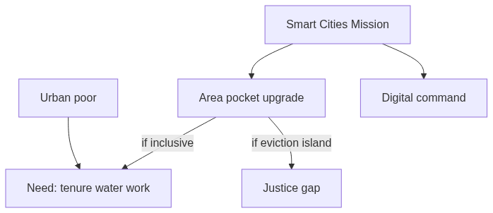
- Island investment: One upgraded pocket can leave the wider city unchanged.
- Eviction risk: Beautification without nearby housing is injustice dressed as development.
- Jobs gap: Cameras and apps do not create secure urban work.
- Vendor exclusion: “World-class” footpaths can erase informal livelihoods.
- Surveillance without service: Watching the poor is not the same as serving them.
- Housing scale: The mission did not abolish slum insecurity at the scale of recent urban growth.
- Balanced verdict: Technology helps only when city-wide basic services and voice move with it.
Flow diagram
Conclusion
Smart city projects can upgrade a chosen area’s lights, roads, and digital desks. Urban poverty and distributive justice need tenure, water, work, and a voice across the whole city. Technology helps only when those goods move with it.
Quick related
Students also ask
-
Do you think that globalization results in only an aggressive consumer culture? Justify your answer.
Next question on this syllabus topic (2025 · Q10). View answer →
-
Did every smart city ignore the poor?
No. Some included markets, shelters and better water. The pattern is still a small geography of investment.
-
Is a command centre justice?
It can speed an ambulance. It is not a substitute for a legal slum house.
Same topic · past papers
UPSC has asked this before
These previous-year questions sit on the same topic. Open one to practise the earlier ask.
More from this topic
Q11 · UPSC Mains 2026 · GS I · 15 marks · Solution
Vijayanagara architecture exemplifies the amalgamation of past traditions with contemporary practices. Elucidate with examples.
Indian Heritage and Culture
• The Vijayanagara architectural style (14th–17th centuries) brilliantly synthesized classical Dravidian traditions with contemporary Deccan innovations. • It preserved grand spatial layouts, towering gopurams, and enclosed prakaras inspired by earlier Chola and Pandya idioms. • Sacred centers maintained canonical sanctum alignments while expanding peripheral structures to encourage greater public participation. • Secular buildings, such as the Lotus Mahal and Elephant Stables, integrated Islamic arched vaults and domes. • Builders utilized locally available hard granite, shifting ornamentation techniques toward bold, deep-relief stone carving. • Innovative structural typologies included multi-shafted composite pillars featuring rearing yalis, horse riders, and hanging brackets. • The Vittalaswami Temple at Hampi showcased pioneering acoustic engineering through famous resonant musical pillars.
Q1 · UPSC Mains 2026 · GS I · 10 marks · Solution
Analyze the importance of Ashokan inscriptions for reconstructing Mauryan history.
Indian Heritage and Culture
Ashokan inscriptions serve as the bedrock for reconstructing Mauryan history by offering authentic, contemporaneous evidence directly from the emperor. Written primarily in Brahmi, Kharosthi, Aramaic, and Greek scripts, they illuminate Ashoka's administrative reach, socio-religious policies, and the moral framework of Dhamma. Distributed across the Indian subcontinent and beyond, these edicts document spatial boundaries, diplomatic ties with Hellenistic kingdoms, and the socio-economic milieu. They bridge the gap between literary accounts and archaeological finds, providing an invaluable indigenous chronology.
Q15 · UPSC Mains 2025 · GS I · 15 marks · Solution
How can Artificial Intelligence (AI) and drones be effectively used along with GIS and RS techniques in locational and areal planning?
Indian Heritage and Culture
Remote sensing supplies pictures of land and water; GIS stores them with administrative boundaries. Drones add cheap, repeatable local maps for disasters, utilities and village layouts. Artificial intelligence classifies pixels and can forecast flood, heat or sprawl on that GIS base. Indian platforms such as Bhuvan and Gati Shakti already try to combine these tools. Planning still needs ground checks and a public purpose, or the map only watches the poor. The four tools are a chain: locate, refresh, read, then choose the public use.