
Revision summary
A cloudburst is a short, very intense convective rainfall over a small area. Indian usage often treats about 100 mm in an hour over a few tens of square kilometres as the mark. The cloud does not literally burst. A thunderstorm cell unloads rain and hail at once. Himalayan orography, monsoon moisture and steep valleys make the hazard famous in India. Western Ghats and some urban thunderstorms can show similar intense cells. Risk is multiplied by roads, hotels and towns on floodways.
Model answer
Copper italics in this answer — like this — are the key facts. Each one is unpacked in the Facts & figures rail.
Introduction
A cloudburst is not ordinary heavy rain with a dramatic name. It is a short, violent dump of water from a convective cloud over a small patch of ground. In the Himalaya that patch is often a valley that cannot drain the water as fast as it arrives. The explanation is atmospheric physics plus mountain shape. It is not a mysterious bursting of a cloud like a bag.
Body
What a cloudburst is
In Indian operational usage, associated with the India Meteorological Department, a cloudburst is typically about 100 mm of rain in an hour over a small area of a few tens of square kilometres. The rain is convective. A tall cumulonimbus has a strong updraft that holds rain and hail. Then a sudden downdraft and collapse unload it. Lightning, gusts and, in mountains, debris flow travel with it. It is mesoscale. It is not a monsoon front painted across a whole State.
The name misleads. The cloud does not “burst”. The precipitation efficiency of a cell becomes extreme for a short time.
- Intensity: The fall is very high millimetres per hour. It is not merely a wet day.
- Scale: The cell covers a few kilometres to a few tens of kilometres. That is why a neighbouring village may stay dry.
- Hazard: Flash flood, landslide and a sudden rise of a nala follow, especially where slopes are steep and channels are clogged.
How and where they form
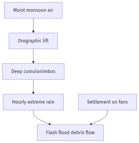
Warm moist air is lifted rapidly. In the Himalaya, orographic lift on south-facing slopes, a monsoon or western-disturbance moisture feed, and a steep lapse rate build deep convection. If a cell stalls against a ridge, rain accumulates in one catchment. The Western Ghats and, less often, arid hills that meet a monsoon surge can see similar cells. Urban cloudburst-like downpours happen when heat and moisture feed thunderstorms over a city. The classic Indian disaster narrative is still Uttarakhand, Himachal, J&K and the Nepal Himalaya.
Forecasting is hard because the cell is small and short-lived. Satellites and Doppler radar help. A warning may still lag the nala. Land use — roads cutting slopes, riverbed mining, hotels on fans — turns a meteorological event into a catastrophe.
- Orography: Mountains force ascent and can trap a cell.
- Moisture and instability: Monsoon air plus heating aloft or cold air above.
- Human exposure: Settlement on floodways makes the same rain deadly.
Kedarnath (2013) and Leh (2010) are remembered as Himalayan hydro-meteorological disasters. Extreme convective rain and mountain geomorphology combined in both. Each event had its own mix of rain, breach and debris. Both sit in the public meaning of a Himalayan cloudburst country.
Flow diagram
Conclusion
A cloudburst is extreme convective rain over a small area in a short time. Mountains produce the lift. Monsoon moisture supplies the fuel. Steep valleys deliver the flood. Policy needs radar, slope science and keeping people off the nala. It does not need a picture of a torn cloud.
Quick related
Students also ask
-
What is the concept of a 'demographic winter'? Is the world moving towards such a situation? Elaborate.
Next question on this syllabus topic (2024 · Q7). View answer →
-
Is every Himalayan flood a cloudburst?
No. Prolonged monsoon rain, glacial lake breach, and landslide dam burst can flood without meeting the hourly cloudburst mark.
-
Can cloudbursts be forecast a day ahead like a cyclone?
Not with the same confidence. The cell is small; nowcasting with radar is more realistic than a long-range map.
More from this topic
Q17 · UPSC Mains 2026 · GS I · 15 marks · Solution
Analyze the major drivers of human-induced land-use changes in India and their geographical consequences.
World's Physical Geography
Anthropogenic pressures driven by population growth and economic development are the primary catalysts of rapid land-use and land-cover change (LULCC) across India. Agricultural expansion and intensive multi-cropping, particularly
Q16 · UPSC Mains 2026 · GS I · 15 marks · Solution
"The centre of global trade is gradually shifting from the Atlantic region to the Indo-Pacific region." Examine this statement.
World's Physical Geography
• The global center of economic gravity has decisively shifted from the Euro-Atlantic axis to the Indo-Pacific. • The rise of China, Southeast Asia, and India as primary manufacturing and consumption hubs drives this transition. • Vital maritime chokepoints like the Malacca Strait serve as critical arteries for global energy and merchant trade. • Mega free-trade agreements such as RCEP and IPEF have established new regional trade and rule-making architectures. • Post-pandemic supply chain vulnerabilities have accelerated diversification strategies like 'China-plus-one' and 'friend-shoring'. • Control over critical mineral supply chains powers the ongoing digital and green energy transitions in the region. • Sustaining this geo-economic shift requires robust multilateral frameworks, freedom of navigation, and rules-based maritime governance.
Q14 · UPSC Mains 2026 · GS I · 15 marks · Solution
Compare the Loo, Chinook and Foehn winds with respect to their regions of prevalence, their nature and climatic impacts.
World's Physical Geography
• Local winds like the Loo, Chinook, and Foehn are driven by distinct regional pressure gradients and orographic barriers. • The Loo prevails over the Indo-Gangetic Plain, the Chinook along the Rockies' eastern slopes, and the Foehn across the northern Alpine valleys. • The Loo is a scorching, dust-laden convective surface wind generated by intense summer continental heating. • Both the Chinook and Foehn are warm, dry katabatic winds formed via rapid adiabatic compression on the leeward sides of mountains. • The Loo induces severe agricultural stress, crop wilting, and high health risks like heat strokes in South Asia. • Chinooks act as 'snow eaters' in North America, rapidly melting winter snowpacks and opening up pasturelands for grazing. • Foehn winds accelerate Alpine snowmelt, which simultaneously triggers hazardous avalanches and elevates regional wildfire risks.