
Revision summary
The Bay of Bengal monsoon current is deflected westward up the Ganga plain. In Bhojpur that rain wind arrives from the east and is named Purvaiya. The Arabian Sea south-westerly is not the local rain-bringer here. Rice, flood, ghats, and Bhojpuri rain songs grew around this seasonal easterly. Culture and monsoon meteorology are one story in this region.
Model answer
Copper italics in this answer — like this — are the key facts. Each one is unpacked in the Facts & figures rail.
Introduction
In the Bhojpuri belt of western Bihar and eastern Uttar Pradesh, the rain-bearing monsoon often arrives as a moist wind from the east. People therefore call that current Purvaiya, even though the larger Indian monsoon is named south-west.
Body
Why the monsoon is Purvaiya here
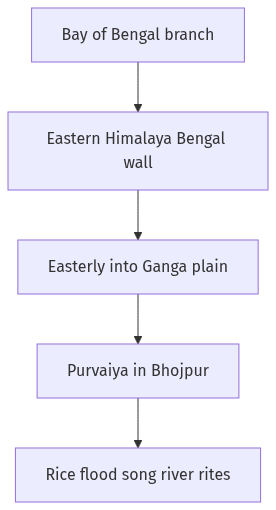
- The Arabian Sea branch of the south-west monsoon moves inland from the west and south-west, but the Bay of Bengal branch strikes the Eastern Himalaya and the Meghalaya–Bengal wall.
- After that strike, a large part of the Bay current is deflected up the Ganga plain as a rain-bearing easterly or south-easterly flow.
- Bhojpur, Buxar, Ara, Ballia, Ghazipur, and neighbouring districts sit where this deflected Bay current, not the dry westerly loo, brings the main kharif rain.
- Local speech therefore names the welcome wet wind Purvaiya, meaning the easterly, which is a ground name for a deflected south-west monsoon current.
- When the Purvaiya is late or weak, paddy and the flood pulse of the Ganga, Ghaghara, and Son fail together, so the name is a climate fact, not a poetic extra.
Influence on cultural ethos
- Wet-rice, sugarcane, and later wheat in a floodplain calendar shaped festivals, work songs, and the waiting for rain in Bhojpuri folk such as kajri and malhar.
- Boat culture, river ghats, and settlement on slightly higher mounds grew because the same easterly rain also means sheet flood and silt.
- Chhath and other river-facing rites in the wider region treat the sun and the river as part of a monsoon agrarian year, even when the exact date is post-monsoon.
- Language, birha, and migration songs record men leaving after harvest, which is a social answer to a densely peopled, flood-prone rice tract.
- Food, thatch, and courtyard life assume humidity and clay, so the ethos is of a wet plain, not of a rain-shadow plateau.
Way forward for the explanation
- Keep the meteorology (Bay deflection) and the culture (rice, flood, song, river rite) on the same wind, or the two parts of the question fall apart.
Flow diagram
Conclusion
The south-west monsoon is called Purvaiya in Bhojpur because the Bay branch reaches this plain as an easterly rain wind. That seasonal direction still shapes rice, flood, river rites, and Bhojpuri song, and climate planning here must treat the Purvaiya as both weather and culture.
Quick related
Students also ask
-
Differentiate the causes of landslides in the Himalayan region and Western Ghats.
Next question on this syllabus topic (2021 · Q4). View answer →
-
Does Purvaiya mean the monsoon is not south-west?
The all-India system is still the south-west monsoon. In this plain the rain-bearing current is a deflected easterly, so the local name is accurate.
-
Is Chhath caused by the Purvaiya?
Chhath is a river-sun rite of the wider region. It sits in an agrarian year that the monsoon and the rivers make possible, not as a direct wind cult.
Same topic · past papers
UPSC has asked this before
These previous-year questions sit on the same topic. Open one to practise the earlier ask.
-
2016 · Q8 · GS I · 12 marks
To what extent globalisation has influenced the core of cultural diversity in India? Explain.
More from this topic
Q15 · UPSC Mains 2026 · GS I · 15 marks · Solution
Analyze the role of satellite-based technologies in achieving climate-smart agriculture and food security in India.
Geophysical Phenomena
Satellite-based technologies are transforming Indian agriculture from a monsoon-dependent gamble into a precision
Q4 · UPSC Mains 2026 · GS I · 10 marks · Solution
What is the Fujiwhara effect? Explain its impact on the movement and intensity of tropical cyclones.
Geophysical Phenomena
The Fujiwhara effect occurs when two neighboring tropical cyclones rotate cyclonically around a common center due to interacting vortex dynamics. It alters the standard movement of cyclones, causing trajectories to deviate, merge, or orbit each other. In terms of intensity, the interaction can suppress the weaker storm while potentially energizing the stronger one. Understanding this phenomenon is vital for improving cyclone track forecasting in regions like the Northwest Pacific and the Bay of Bengal. Meteorological agencies use advanced numerical models to predict these complex binary cyclone interactions. Proper tracking mitigates coastal disaster risks by providing timely warnings for erratic landfall paths.
Q7 · UPSC Mains 2025 · GS I · 10 marks · Solution
What are Tsunamis? How and where are they formed? What are their consequences? Explain with examples.
Geophysical Phenomena
A tsunami is a train of long ocean waves caused by sudden motion of the seafloor. Most begin on subduction megathrusts; landslides and volcanoes can also trigger them. In deep water they are fast and low; near shore they flood. The 2004 Sumatra quake devastated the Andamans, Tamil Nadu, Sri Lanka, the Maldives and coasts as far as Africa. Warning systems work only with drills, and mangroves take some of the blow. The Makran zone remains a local tsunami source for India’s west coast.