
Revision summary
Surface currents are driven mainly by winds, turned by Coriolis, and steered by coasts. Density differences drive slower deep thermohaline flow; monsoons reverse the north Indian Ocean. Upwelling eastern-boundary currents feed the great anchovy and sardine industries. Warm–cold mixing off Japan and the Grand Banks feeds rich mixed fisheries. El Niño and overfishing show that current wealth is not a guaranteed harvest.
Model answer
Copper italics in this answer — like this — are the key facts. Each one is unpacked in the Facts & figures rail.
Introduction
Ocean currents are slow rivers of seawater driven by wind, earth rotation, density, and the shape of basins. Where they lift nutrients or mix warm and cold water, the world’s great fisheries gather.
Body
Forces that drive currents
- Prevailing winds, especially the trades and westerlies, drag the surface and set gyres in each ocean basin.
- The Coriolis force turns moving water to the right in the north and to the left in the south, which closes those gyres and sets western boundary currents such as the Gulf Stream and Kuroshio.
- Temperature and salinity make density differences, so thermohaline flow moves deep water in a slower global conveyor.
- Continents, narrow straits, and the equator deflect and pile water, which creates coastal currents and equatorial counter-currents.
- Seasonal monsoon winds reverse surface flow in the north Indian Ocean, which is why the Somali current can flip with the year.
- Tides and storms matter locally; they do not replace the planetary wind-and-density engine.
How currents feed fisheries
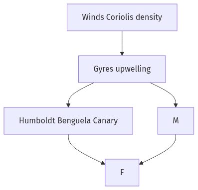
- Wind-driven upwelling along eastern ocean boundaries lifts nitrate-rich water, which grows plankton and then small pelagic fish.
- The Humboldt (Peru), Benguela, Canary, and California systems are the classic upwelling fisheries of anchovy, sardine, and related stocks.
- Mixing of warm and cold currents, as where the Kuroshio meets the Oyashio off Japan, or on the Grand Banks where the Gulf Stream system meets Labrador water, creates fog, plankton blooms, and dense demersal fisheries.
- Monsoon upwelling off Somalia and the south-west Indian coast supports seasonal pelagic catches in the Arabian Sea.
- Warm currents also carry tuna and other migratory species along predictable highways that industrial fleets follow.
Industry, risk, and climate
- The world’s largest industrial catches historically clustered on these current edges, not on still tropical lagoons.
- El Niño can shut Peru’s upwelling, crash anchovy, and ripple fishmeal and food prices, which shows that the fishery is a climate-current couple.
- Overfishing, not the current, now limits many stocks; the current only sets where biology could be rich.
- For India, the monsoon current and coastal upwelling matter for oil sardine and related west-coast fisheries, while the open Bay is a different current regime.
Flow diagram
Conclusion
Winds, Coriolis, density, and basin shape make ocean currents. Their role in fishing is to create upwelling and mixing zones where plankton and fish concentrate; climate swings and overfishing then decide whether that gift is landed or lost.
Quick related
Students also ask
-
Despite India being one of the countries of the Gondwanaland, its mining industry contributes much less to its Gross Domestic Product(GDP) in percentage. Discuss.
Next question on this syllabus topic (2021 · Q5). View answer →
-
Do fish follow only warm currents?
No. Many of the densest catches sit on cold upwelling or on warm–cold fronts.
-
Is the Indian Ocean poor in current fisheries?
It has monsoon upwelling and tuna routes. It is not a Humboldt-scale eastern-boundary factory in the same way.
Same topic · past papers
UPSC has asked this before
These previous-year questions sit on the same topic. Open one to practise the earlier ask.
More from this topic
Q7 · UPSC Mains 2026 · GS I · 10 marks · Solution
"Water resources are both an asset and a source of conflict in South Asia." Examine this statement giving examples.
Natural Resources and Industries
• South Asian river systems drive regional economies through massive agricultural irrigation and vital hydropower generation. • Rapid population growth and climate change have increasingly turned these shared lifelines into geopolitical flashpoints. • India-Pakistan water friction persists through disputes over run-of-the-river hydroelectric projects under the Indus Waters Treaty. • Unresolved bilateral deadlocks, such as the Teesta river sharing impasse, highlight complex domestic political challenges. • Upstream Chinese dam construction on the Brahmaputra creates severe ecological and strategic anxiety for downstream nations. • Effective regional stability requires moving away from zero-sum basin nationalism toward cooperative hydro-diplomacy. • Institutional frameworks must treat shared river basins as common ecological trusts to ensure sustainable regional development.
Q14 · UPSC Mains 2025 · GS I · 15 marks · Solution
Give a geographical explanation of the distribution of off-shore oil reserves of the world. How are they different from the on-shore occurrences of oil reserves?
Natural Resources and Industries
Offshore oil lies in sedimentary traps on continental shelves and slopes. Major provinces include the Persian Gulf, North Sea, Gulf of Mexico, West Africa, Brazil's pre-salt, and India's Mumbai High and KG basin. The geology is kin to onshore basins; the difference is water depth, platforms and spill behaviour. Onshore fields are usually cheaper to develop and easier for a state to hold physically. Disputed seas turn offshore oil into a geopolitical resource, not only a geological one. Deep water is capital-heavy, so price slumps hit it first.
Q14 · UPSC Mains 2023 · GS I · 15 marks · Solution
Comment on the resource potentials of the long coastline of India and highlight the status of natural hazard preparedness in these areas.
Natural Resources and Industries
India’s coast and EEZ hold fish, ports, offshore energy, beach minerals, salt, and tourism. Cyclones, the 2004 tsunami, surge, and erosion are the main natural hazards. The Disaster Management Act, 2005, IMD, INCOIS, and cyclone shelters have lowered death counts. CRZ rules and mangrove buffers are unevenly enforced. Ports and fishers need the same map of hazard before the next surge.