
Revision summary
Winds, unequal heating and salinity, Coriolis force, and continent shape originate ocean currents. The north Indian Ocean also reverses with the monsoon winds. Warm currents milden high-latitude west coasts; cold currents cool and dry some west coasts. Upwelling currents support the richest fisheries. Navigators still use gyres and monsoon flows and must watch fog and ice on cold-current shores.
Model answer
Copper italics in this answer — like this — are the key facts. Each one is unpacked in the Facts & figures rail.
Introduction
Ocean currents are large, fairly steady flows of seawater. They begin because the sun, wind, and Earth’s rotation heat and push the sea unevenly, and because continents block the water. Those flows then move heat, nutrients, and ships, so they are a climate, food, and trade fact, not only a map colour.
Body
Factors responsible for origin and pattern
- Planetary winds, especially the trade winds and westerlies, drag the surface and start the great gyres in each ocean basin.
- Unequal heating of equator and poles creates density differences: warm, lighter water and cold, denser water that sink and rise in a slow conveyor.
- Salinity changes from evaporation, rainfall, ice melt, and river input also change density and help drive deep and surface flows.
- The Coriolis effect, from Earth’s rotation, turns currents to the right in the northern hemisphere and to the left in the southern, which shapes gyres and western boundary currents.
- Shape of continents, narrow straits, and the mid-ocean ridges steer, split, or speed the flow, as at the Cape of Good Hope or the Florida Strait.
- In the north Indian Ocean, the reversing monsoon winds reverse surface currents seasonally, which is a special case of wind drive.
- Tides and local coastal winds add smaller currents, but the main origin story is wind plus density plus rotation plus basin shape.
Influence on regional climates
- Warm currents such as the Gulf Stream and North Atlantic Drift keep northwest Europe milder and wetter than other places at the same latitude.
- Cold currents such as the Humboldt (Peru), Benguela, and California currents cool west coasts, raise fog and aridity, and help make coastal deserts.
- The Kuroshio warms Japan’s east; the Labrador Current cools eastern Canada and feeds fog on the Grand Banks where it meets warmer water.
- El Niño is a breakdown of the usual Pacific cold upwelling pattern and shows how current and wind shifts can change rainfall far inland, including the Indian monsoon in some years.
Fishing
- Upwelling along Peru, California, and Benguela brings nutrients to the surface and supports huge fisheries, until El Niño or overfishing cuts the catch.
- Mixing zones on banks and at current edges concentrate plankton and fish, which is why some of the world’s great fisheries sit on current maps.
- Warm, nutrient-poor tropical gyre centres are poorer in fish than cold upwelling coasts.
Navigation
- Sail and steam both used or fought known currents: the Gulf Stream for the North Atlantic crossing, and monsoon currents in the Arabian Sea and Bay of Bengal for historic Indian Ocean trade.
- Today, routing still saves fuel by riding currents and avoiding adverse flow; ice and fog on cold-current coasts remain hazards.
- Oil spills and plastic also follow current paths, which is a modern navigation and disaster fact.
Way forward for the answer
- List wind, density, Coriolis, and continents first, then one climate, one fishery, and one shipping example each.
Flow diagram
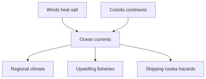
Conclusion
Ocean currents start from wind drag, heat and salt density, Earth’s spin, and the walls of the continents. They milden or dry coasts, feed upwelling fisheries, and still guide ships. To know a region’s climate and fish, one must know the current at its shore.
Quick related
Students also ask
-
How far do you agree that the behaviour of the Indian monsoon has been changing due to humanizing landscape? Discuss.
Next question on this syllabus topic (2015 · Q18). View answer →
-
Do tides create the great ocean currents?
Tides make local coastal currents. The great gyres are mainly wind- and density-driven, turned by Coriolis force.
-
Why are some deserts on west coasts?
Cold currents cool the air, reduce rainfall, and often sit with upwelling and stable high pressure.
Same topic · past papers
UPSC has asked this before
These previous-year questions sit on the same topic. Open one to practise the earlier ask.
-
2022 · Q14 · GS I · 15 marks
What are the forces that influence ocean currents? Describe their role in fishing industry of the world. -
2023 · Q15 · GS I · 15 marks
Identify and discuss the factors responsible for diversity of natural vegetation in India. Assess the significance of wildlife sanctuaries in rain forests regions of India.
More from this topic
Q15 · UPSC Mains 2026 · GS I · 15 marks · Solution
Analyze the role of satellite-based technologies in achieving climate-smart agriculture and food security in India.
Geophysical Phenomena
Satellite technologies support climate-smart agriculture by monitoring crop acreage, yield, soil moisture, vegetation health, weather extremes, droughts and floods. Their value increases when linked to agromet advisories, PMFBY, procurement planning, resource efficiency and farmer-facing digital platforms.
Q4 · UPSC Mains 2026 · GS I · 10 marks · Solution
What is the Fujiwhara effect? Explain its impact on the movement and intensity of tropical cyclones.
Geophysical Phenomena
• Fujiwhara effect is the mutual rotation of two nearby cyclonic vortices. • The systems move around a common barycentre. • Similar-strength storms may orbit, while unequal storms may merge or one may absorb the other. • Tracks can loop, slow, recurve or shift suddenly. • Intensity can weaken through shear or change after merger. • A broader rain and wind field can raise disaster risk even without dramatic strengthening. • It makes cyclone forecasting more uncertain.
Q7 · UPSC Mains 2025 · GS I · 10 marks · Solution
What are Tsunamis? How and where are they formed? What are their consequences? Explain with examples.
Geophysical Phenomena
A tsunami is a train of long ocean waves caused by sudden motion of the seafloor. Most begin on subduction megathrusts; landslides and volcanoes can also trigger them. In deep water they are fast and low; near shore they flood. The 2004 Sumatra quake devastated the Andamans, Tamil Nadu, Sri Lanka, the Maldives and coasts as far as Africa. Warning systems work only with drills, and mangroves take some of the blow. The Makran zone remains a local tsunami source for India’s west coast.