
Revision summary
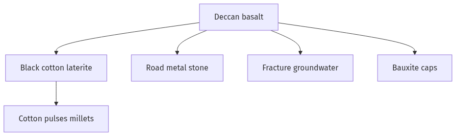
The Deccan Trap is a huge basalt plateau of late Cretaceous to early Cenozoic age. It supplies building stone and weathers to black cotton soil and laterite. Cotton, soybean, and dry millets ride that soil. Fractured basalt holds patchy groundwater; rivers still matter for irrigation. Bauxite and some other ores sit on or beside lateritised trap country.
Model answer
Copper italics in this answer — like this — are the key facts. Each one is unpacked in the Facts & figures rail.
Introduction
The Deccan Trap is a vast Cretaceous–Paleogene basalt pile across Maharashtra and neighbouring states. Its resource potential is the lava itself, the soils it weathers into, and the minerals and water stored in its layers.
Body
Rock, soil, and farming
- Flood basalts yield road metal, railway ballast, and building stone on a continental scale.
- Weathering produces black cotton soil (regur), which holds moisture and supports cotton, soybean, sorghum, and pulses in Maharashtra, Madhya Pradesh, and Gujarat.
- Laterite caps on trap plateaus give brick earth and, in places, bauxite-rich profiles.
- Inter-trappean beds hold thin sediments and fossils; they also mark breaks where soils and aquifers can sit.
Minerals and energy-related uses
- Bauxite on lateritised trap and nearby plateaus feeds aluminium in parts of Maharashtra, Chhattisgarh, and Odisha’s border belts.
- Iron, manganese, and some limestone occur in and around the trap country, though the richest iron belts of India are not only trap rock.
- Vesicular and fractured basalt stores groundwater in shallow unconfined systems, which dug wells and tanks have long used, even if yields are patchy.
- Geothermal and ornamental-stone uses exist locally; they are secondary to soil and aggregate.
Limits of the potential
- Poorly managed black soil erodes into gullies, and rain-fed cotton belts remain drought-prone.
- Hard compact basalt is a poor deep aquifer unless fractures connect, so irrigation still leans on rivers such as the Godavari, Krishna, and Tapi.
- Resource wealth is therefore agricultural and construction-led, not a hidden oil province inside the lava pile.
Flow diagram
Conclusion
Deccan Trap potential is basalt aggregate, black cotton and laterite soils, patchy groundwater, and plateau bauxite. It is a farming and building storehouse, not an unlimited mineral sea.
Quick related
Students also ask
-
What are the forces that influence ocean currents? Describe their role in fishing industry of the world.
Next question on this syllabus topic (2022 · Q14). View answer →
-
Is the whole Deccan Trap rich in petroleum?
The lava pile itself is not a classic oil reservoir. Hydrocarbons in western India sit mainly in sedimentary basins beside or below volcanic cover.
-
Why is cotton tied to this region?
Regur’s clay and moisture-holding suit rain-fed cotton better than many red soils of the open shield.
Same topic · past papers
UPSC has asked this before
These previous-year questions sit on the same topic. Open one to practise the earlier ask.
More from this topic
Q7 · UPSC Mains 2026 · GS I · 10 marks · Solution
"Water resources are both an asset and a source of conflict in South Asia." Examine this statement giving examples.
Natural Resources and Industries
• South Asian river systems drive regional economies through massive agricultural irrigation and vital hydropower generation. • Rapid population growth and climate change have increasingly turned these shared lifelines into geopolitical flashpoints. • India-Pakistan water friction persists through disputes over run-of-the-river hydroelectric projects under the Indus Waters Treaty. • Unresolved bilateral deadlocks, such as the Teesta river sharing impasse, highlight complex domestic political challenges. • Upstream Chinese dam construction on the Brahmaputra creates severe ecological and strategic anxiety for downstream nations. • Effective regional stability requires moving away from zero-sum basin nationalism toward cooperative hydro-diplomacy. • Institutional frameworks must treat shared river basins as common ecological trusts to ensure sustainable regional development.
Q14 · UPSC Mains 2025 · GS I · 15 marks · Solution
Give a geographical explanation of the distribution of off-shore oil reserves of the world. How are they different from the on-shore occurrences of oil reserves?
Natural Resources and Industries
Offshore oil lies in sedimentary traps on continental shelves and slopes. Major provinces include the Persian Gulf, North Sea, Gulf of Mexico, West Africa, Brazil's pre-salt, and India's Mumbai High and KG basin. The geology is kin to onshore basins; the difference is water depth, platforms and spill behaviour. Onshore fields are usually cheaper to develop and easier for a state to hold physically. Disputed seas turn offshore oil into a geopolitical resource, not only a geological one. Deep water is capital-heavy, so price slumps hit it first.
Q14 · UPSC Mains 2023 · GS I · 15 marks · Solution
Comment on the resource potentials of the long coastline of India and highlight the status of natural hazard preparedness in these areas.
Natural Resources and Industries
India’s coast and EEZ hold fish, ports, offshore energy, beach minerals, salt, and tourism. Cyclones, the 2004 tsunami, surge, and erosion are the main natural hazards. The Disaster Management Act, 2005, IMD, INCOIS, and cyclone shelters have lowered death counts. CRZ rules and mangrove buffers are unevenly enforced. Ports and fishers need the same map of hazard before the next surge.