
Revision summary
Dead zones are hypoxic waters, often seasonal, driven by nutrient pollution and warming. Bottom animals die; mobile fish flee into crowded oxygenated belts. Food webs shift toward microbes and jellyfish and away from commercial stocks. Seagrass, coral, and mangrove nurseries suffer on eutrophic coasts. The Gulf of Mexico, Baltic, and parts of the Arabian Sea show the global spread.
Model answer
Copper italics in this answer — like this — are the key facts. Each one is unpacked in the Facts & figures rail.
Introduction
Dead zones are sea areas where dissolved oxygen falls so low that most animals cannot live there. They spread when nutrients from farms and cities feed algal blooms that then rot and use up oxygen, especially in summer on still shelves.
Body
How a dead zone forms
- Rivers such as the Mississippi, the Yangtze, and Indian estuaries of the Ganga–Brahmaputra and Godavari carry nitrogen and phosphorus from fertiliser, sewage, and livestock.
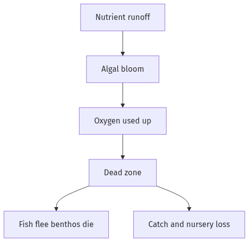
- Algae bloom, die, and sink; bacteria consume oxygen in the bottom water, creating hypoxia or anoxia.
- Stratification in warm months traps that low-oxygen layer, so the zone returns each year and can grow with more nutrient load and with climate-driven warming, which holds less oxygen.
Consequences for the ecosystem
- Fish, shrimp, and crabs flee or die; benthic animals that cannot swim, such as clams and worms, suffocate, so the seafloor community collapses.
- Food webs shorten: jellyfish and some microbes may persist while commercial finfish and shellfish lose nursery and feeding ground.
- Hypoxia forces remaining fish into thinner oxygenated water, which raises stress, disease, and easy capture, then a crash in catch.
- Dead organic matter and hydrogen sulphide can create black, lifeless mud; recovery of diversity is slow even if oxygen returns for a season.
- Coral, seagrass, and mangrove edges near eutrophic coasts lose light and oxygen, so coastal carbon stores and fish nurseries shrink together.
- Global spread of dead zones, from the Gulf of Mexico to the Baltic and parts of the Arabian Sea, cuts the ocean’s role as a protein source for coastal people.
Way forward
- Cut fertiliser runoff, treat sewage, and restore wetlands that trap nutrients before they reach the shelf.
- Treat warming seas as a partner of nutrient pollution, because a warmer ocean holds less oxygen and keeps the dead zone in place.
Flow diagram
Conclusion
Spreading dead zones empty the seafloor of animals, push fish away, and shrink coastal nurseries. The marine ecosystem pays in diversity and in catch until nutrients and warming are both reduced.
Quick related
Students also ask
-
Discuss whether formation of new states in recent times is beneficial or not for the economy of India.
Next question on this syllabus topic (2018 · Q12). View answer →
-
Are dead zones completely without life?
Almost for animals that need oxygen. Bacteria and some tolerant microbes remain. The ecosystem people use is gone.
-
Can a dead zone recover?
Yes, if nutrient input falls and mixing returns oxygen, as parts of the Black Sea showed after fertiliser use dropped. Recovery of animals takes years.
Same topic · past papers
UPSC has asked this before
These previous-year questions sit on the same topic. Open one to practise the earlier ask.
-
2019 · Q15 · GS I · 15 marks
How can the mountain ecosystem be restored from the negative impact of development initiatives and tourism?
More from this topic
Q17 · UPSC Mains 2026 · GS I · 15 marks · Solution
Analyze the major drivers of human-induced land-use changes in India and their geographical consequences.
World's Physical Geography
India's land-use change is driven by agricultural intensification, urban growth, infrastructure, mining, plantations, tourism and livelihood shifts. These changes support food, connectivity and jobs, but they also disturb hydrology, soil, habitats, microclimates, hills, coasts and access to commons. Sustainable land governance must combine mapping, carrying-capacity assessment and local participation.
Q16 · UPSC Mains 2026 · GS I · 15 marks · Solution
"The centre of global trade is gradually shifting from the Atlantic region to the Indo-Pacific region." Examine this statement.
World's Physical Geography
Global trade’s centre of gravity is moving towards the Indo-Pacific because manufacturing, consumption, energy shipping and new tech rules are concentrating between the Indian and Pacific Oceans. China-plus-one, ASEAN growth, India’s market, Malacca–Hormuz lanes, RCEP/IPEF and semiconductor corridors drive the trend. The Atlantic still matters in finance and standards, so the change is gradual rebalancing. India gains only if ports, manufacturing and sea-lane security keep pace.
Q14 · UPSC Mains 2026 · GS I · 15 marks · Solution
Compare the Loo, Chinook and Foehn winds with respect to their regions of prevalence, their nature and climatic impacts.
World's Physical Geography
The Loo is a hot, dusty pre-monsoon wind of northwestern India and the Indo-Gangetic plains. Chinook and Foehn are warm, dry downslope winds of the Rockies and Alps, formed by adiabatic compression. Their impacts differ from Indian heat stress to snowmelt and mountain hazards.