
Revision summary
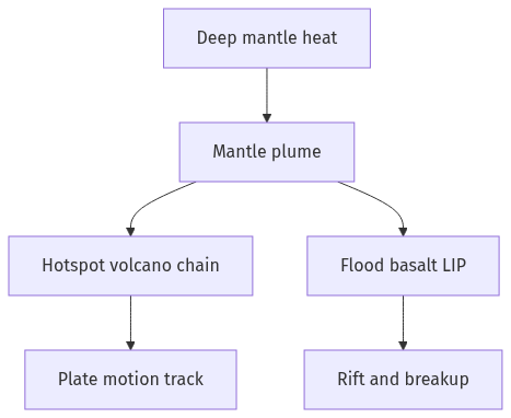
A mantle plume is a hot column rising through the mantle toward the lithosphere. Its head can make a large igneous province; its tail can feed a long hotspot. Hawaii shows an oceanic track; Deccan–Reunion shows a continental flood then a track. Plumes can dome and rift plates and add melt at ridges such as Iceland. They supplement, and do not replace, ridge-push and slab-pull.
Model answer
Copper italics in this answer — like this — are the key facts. Each one is unpacked in the Facts & figures rail.
Introduction
A mantle plume is a narrow, hot upwelling of rock from deep in the mantle toward the base of the lithosphere. It is not a plate boundary by itself, but it can burn through a plate, feed volcanoes, and help a continent split.
Body
Definition
- In the plume model, a thermal anomaly rises from the core–mantle boundary or from the mid-mantle as a mushroom-shaped head and a thinner tail.
- When the head reaches the base of the crust it melts, producing a large igneous province; the tail may keep a long-lived hotspot as the plate drifts above it.
- The Hawaiian–Emperor chain is the classic ocean example: a fixed melt source and a moving Pacific plate leave a line of islands and seamounts.
- The Reunion hotspot and the Deccan Traps show the same idea on a continent: a flood-basalt burst, then a hotspot track toward the Indian Ocean.
Role in plate tectonics
- Plumes add heat and magma that thin and dome the lithosphere, so rifts can open; the Afar region and the Ethiopian traps sit where a plume and three rifts meet.
- Flood basalts such as the Deccan, Siberian, and Columbia River provinces show that a plume head can cover huge areas in a short geologic time and may stress climate and life.
- Hotspot tracks give a reference for plate motion, because the volcano age increases away from the active island, as in Hawaii.
- Plumes interact with mid-ocean ridges, as near Iceland, where extra melt builds a high plateau on a spreading centre.
- They do not replace slab-pull and ridge-push as the main motors of plates, but they are a vertical heat engine that can start breakup and decorate plates with chains of volcanoes.
Way forward for the answer
- Define the plume as deep hot upwelling, then show hotspot tracks and flood basalts as its surface role.
- Keep plate tectonics as the horizontal machine and the plume as a deep extra.
Flow diagram
Conclusion
A mantle plume is a deep thermal upwelling that melts the lithosphere from below. In plate tectonics it explains hotspots, flood basalts, and some rifts, while the plates still move mainly by their own ridges and slabs.
Quick related
Students also ask
-
What are the consequences of spreading of 'Dead Zones' on marine ecosystem?
Next question on this syllabus topic (2018 · Q7). View answer →
-
Is every volcano a mantle plume?
No. Most volcanoes sit on subduction zones and mid-ocean ridges. Plumes explain intra-plate hotspots and some flood basalts.
-
Do plumes move the plates?
They add heat and can help rifting. The main plate motors remain slab-pull and ridge processes.
More from this topic
Q17 · UPSC Mains 2026 · GS I · 15 marks · Solution
Analyze the major drivers of human-induced land-use changes in India and their geographical consequences.
World's Physical Geography
India's land-use change is driven by agricultural intensification, urban growth, infrastructure, mining, plantations, tourism and livelihood shifts. These changes support food, connectivity and jobs, but they also disturb hydrology, soil, habitats, microclimates, hills, coasts and access to commons. Sustainable land governance must combine mapping, carrying-capacity assessment and local participation.
Q16 · UPSC Mains 2026 · GS I · 15 marks · Solution
"The centre of global trade is gradually shifting from the Atlantic region to the Indo-Pacific region." Examine this statement.
World's Physical Geography
Global trade’s centre of gravity is moving towards the Indo-Pacific because manufacturing, consumption, energy shipping and new tech rules are concentrating between the Indian and Pacific Oceans. China-plus-one, ASEAN growth, India’s market, Malacca–Hormuz lanes, RCEP/IPEF and semiconductor corridors drive the trend. The Atlantic still matters in finance and standards, so the change is gradual rebalancing. India gains only if ports, manufacturing and sea-lane security keep pace.
Q14 · UPSC Mains 2026 · GS I · 15 marks · Solution
Compare the Loo, Chinook and Foehn winds with respect to their regions of prevalence, their nature and climatic impacts.
World's Physical Geography
The Loo is a hot, dusty pre-monsoon wind of northwestern India and the Indo-Gangetic plains. Chinook and Foehn are warm, dry downslope winds of the Rockies and Alps, formed by adiabatic compression. Their impacts differ from Indian heat stress to snowmelt and mountain hazards.