
Revision summary
After 1707 the Mughal emperor lost the capacity to rule provinces in fact. Nadir Shah and Abdali exposed Delhi’s military hollowness. Bengal, Awadh, Hyderabad, Marathas, Sikhs, and Mysore became separate armed powers. Panipat 1761 showed even the Marathas were not a single state. Company victories in the Carnatic and Bengal fitted into this broken order.
Model answer
Copper italics in this answer — like this — are the key facts. Each one is unpacked in the Facts & figures rail.
Introduction
By the 1740s and 1750s the Mughal emperor at Delhi still claimed Hindustan, but real power sat with many courts and armies. Mid-eighteenth century India was a map of overlapping claims, which is what a fragmented polity means in practice.
Body
Collapse of a single imperial centre
- After Aurangzeb’s death in 1707, weak successors, jagir crisis, and court factions made Delhi unable to tax or police the provinces as before.
- Nadir Shah’s sack of Delhi in 1739 and Ahmad Shah Abdali’s later raids showed that the capital could not defend itself, which invited every regional player to act on his own.
- The emperor became a symbol that Nawabs and Marathas used, not a master who appointed and removed them at will.
Successor states and warrior polities
- Awadh, Bengal–Bihar–Orissa, and Hyderabad under the Nizam were Mughal provinces that ran as near-independent kingdoms with their own armies and revenue.
- The Maratha confederacy after the Peshwas spread through malwa and the north, but Holkar, Scindia, Bhonsle, and Gaekwad pulled in different directions, as the disaster at Panipat in 1761 made clear.
- The Sikhs in the Punjab, Rohillas in the upper Ganga, Jats around Bharatpur, and Mysore under Haidar Ali added more armed centres that did not share one law.
- Rajput states bargained with Marathas and Mughals by turn, which multiplied treaties instead of one imperial peace.
Foreign companies in the gaps
- The English and French East India Companies fought in the Carnatic and then the English captured Bengal after Plassey (1757), inserting a European fiscal-military state into the broken Mughal order.
- Fragmentation was therefore not only Indian regionalism; it was also the opening through which Company diplomacy and private armies entered.
Way forward
- Describe fragmentation as many sovereignties, not as an empty land, because successor states were often vigorous.
- Link the spectre to security and trade: no single power could guarantee the roads from Bengal to Delhi or from Surat to the Deccan.
Flow diagram
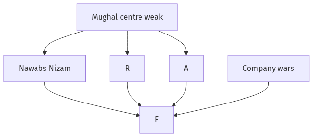
Conclusion
Mid-eighteenth century India was beset by a fragmented polity because the Mughal centre had failed while Nawabs, Marathas, Afghans, and European companies all claimed pieces of the same realm. Unity of the map existed only as a fading imperial name.
Quick related
Students also ask
-
Mention the advantages of the cultivation of pulses because of which the year 2016 was declared as the International Year of Pulses by United Nations.
Next question on this syllabus topic (2017 · Q7). View answer →
-
Was India a vacuum with no states in 1750?
No. It had many strong regional states. Fragmentation means no one centre, not the absence of government.
-
Did the Mughal emperor disappear?
No. He remained a source of titles. Real armies and taxes had already moved to Nawabs, Peshwas, and later the Company.
Same topic · past papers
UPSC has asked this before
These previous-year questions sit on the same topic. Open one to practise the earlier ask.
More from this topic
Q17 · UPSC Mains 2026 · GS I · 15 marks · Solution
Analyze the major drivers of human-induced land-use changes in India and their geographical consequences.
World's Physical Geography
India's land-use change is driven by agricultural intensification, urban growth, infrastructure, mining, plantations, tourism and livelihood shifts. These changes support food, connectivity and jobs, but they also disturb hydrology, soil, habitats, microclimates, hills, coasts and access to commons. Sustainable land governance must combine mapping, carrying-capacity assessment and local participation.
Q16 · UPSC Mains 2026 · GS I · 15 marks · Solution
"The centre of global trade is gradually shifting from the Atlantic region to the Indo-Pacific region." Examine this statement.
World's Physical Geography
Global trade’s centre of gravity is moving towards the Indo-Pacific because manufacturing, consumption, energy shipping and new tech rules are concentrating between the Indian and Pacific Oceans. China-plus-one, ASEAN growth, India’s market, Malacca–Hormuz lanes, RCEP/IPEF and semiconductor corridors drive the trend. The Atlantic still matters in finance and standards, so the change is gradual rebalancing. India gains only if ports, manufacturing and sea-lane security keep pace.
Q14 · UPSC Mains 2026 · GS I · 15 marks · Solution
Compare the Loo, Chinook and Foehn winds with respect to their regions of prevalence, their nature and climatic impacts.
World's Physical Geography
The Loo is a hot, dusty pre-monsoon wind of northwestern India and the Indo-Gangetic plains. Chinook and Foehn are warm, dry downslope winds of the Rockies and Alps, formed by adiabatic compression. Their impacts differ from Indian heat stress to snowmelt and mountain hazards.